Pro Field Report
Basic Information
Observation Details
Observation Date:
January 3, 2020Submitted:
January 3, 2020Observer:
SAC - LundyZone or Region:
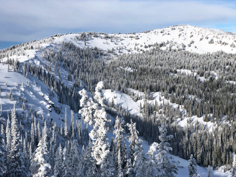
Banner SummitLocation:
Cape HornSigns of Unstable Snow
Recent Avalanches?
None ObservedCracking?
IsolatedCollapsing?
IsolatedSnow Stability
Stability Rating:
FairConfidence in Rating:
HighStability Trend:
ImprovingBottom Line
Similar to yesterday's observation from Frenchmans, the 12/31 storm did not add enough load for widespread avalanche activity. Still, the added load is keeping buried weak layers reactive in tests and triggering a slide remains possible.
Media/Attachments
Advanced Information
Weather Summary
Cloud Cover:
Mostly CloudyWind:
Light , WSkies began OVC, then decreased to SCT by early afternoon, then increased back to BKN. The hour or two of SCT clouds allowed some solar radiation to affect sunny slopes. Winds were occasionally MOD, but not much snow was moving. Temps overall were cooler than expected.
Avalanche Observations
| # | Date | Location | Size | Type | Bed Sfc | Depth | Trigger | Comments | Photo |
|---|---|---|---|---|---|---|---|---|---|
| Several |
Steep slopes at a variety of aspects and elevations |
D1 | SS | I-New/Old Interface | 30cm | N-Natural | Numerous small storm slabs on steep slopes, including in sheltered treed terrain. | None | |
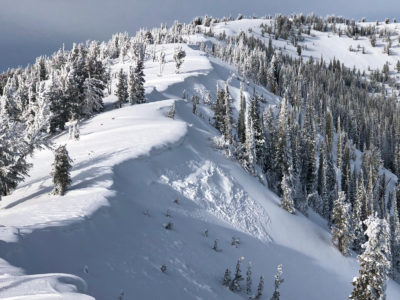
| 2 |
Cape Horn Ridge NE 8900 |
D1 | HS | I-New/Old Interface | N-Natural | Two wind slabs that released and didn't go far. |
|
||
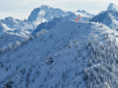
| 1 |
Top of Copper Mtn NE 8900 |
D2 | SS | U-Unknown | Assume a natural but can't say for certain given skier traffic on Copper. Suspect this was a wind slab, but can't gauge from the photo whether it broke into deeper weak layers. |
|
All noted avalanches ran during or just after the 12/31 storm. Not as much avalanche activity as expected, although a lot of the steep, shady slopes in this area ran in mid December.
Snowpack Observations
Snowpack observations were from 6700 to 9000', SW-S-SE-E-NE.
Average depth ranged from 40-50cm at the highway to ~100cm on upper elevation shady. Solars at all elevations were quite thin. 25-30cm of new snow from the 12/31 storm, higher density than what I found in Frenchmans and what's been reported on Galena. No issues at the 12/31 I.F. were observed in handpits or snowpits.
Low elevations and mid elevation solars are thin - the 12/31 storm fell onto a shallow/weak snowpack. Generally no issues in these areas unless you find an area that's been windloaded. We got a couple small to medium collapses on a mid elevation open ridge.
@8150, SE: HS=80cm. 12/7 SH barely visible 67cm down - ECTP22.
@8800, ENE: HS=105cm. 12/7 SH down 60cm - ECTX, PST32/100end. The SH layer seems to be thinning and looking at it closely it seemed to be integrating into layers above and below. 11/26 FC/crust/DH down 75cm - ECTX, PST40/100end.
Stomped on some cornices and wind slabs with no results.
Avalanche Problems
| Problem | Location | Distribution | Sensitivity | Size | Comments |
|---|---|---|---|---|---|
| None Specified |
|
Layer Depth/Date: 60-70cm: 12/7, 70-80cm: 11/26 Comments: The wind slab problem seems to have run it's course in this area. |
Terrain Use
Avoided avalanche terrain, but would have felt comfortable stepping out into low 30 degree terrain without serious consequences.