Pro Field Report
Basic Information
Observation Details
Observation Date:
March 3, 2020Submitted:
March 3, 2020Observer:
SAC - DavisZone or Region:
Soldier and Wood River Valley MtnsLocation:
Couch Summit to S. Fork BoiseSigns of Unstable Snow
Recent Avalanches?
None ObservedCracking?
None ExperiencedCollapsing?
None ExperiencedSnow Stability
Stability Rating:
Very GoodConfidence in Rating:
HighStability Trend:
SteadyBottom Line
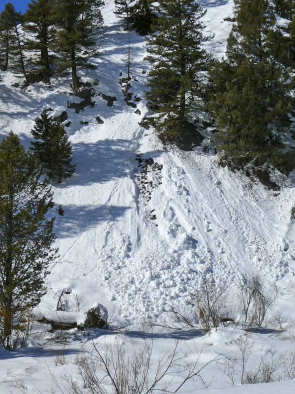
I did not encounter any avalanche hazard today in the middle and lower elevation terrain that I rode in. There were about a dozen old gouging wet loose slides, mostly at low elevation near Little Smoky Creek.
When I wasn't on hardpack, icy old drifts, or a stout crust (in the morning) I was wallowing in weak facets with no distinct weak layers.
The overall snowpack is deeper in the Soldiers than in the WRV, but is still quite thin. Snow totals in the S. Fork of the Boise are maybe 30-40% deeper than at similar elevations near Smoky Bar and south.
Media/Attachments
Advanced Information
Weather Summary
Cloud Cover:
ClearTemperature:
Low 40s FWind:
Light , NWClear and hot. Gusty NW wind.
Avalanche Observations
The wet loose I saw were older (end of last week?). They were mostly D1-D1.5 and a couple were large enough to put 3' of debris across the road. Barring an additional storm, I'd guess these slides are a good indication of the type of warming-related activity we'll see with this garbage snowpack.
Snowpack Observations
Big Smoky and South:
A patchwork of sage/dirt and icy drifts. Still more coverage than the WRV but not by much. HS ~ 40-60 cm on shaded middle elevations.
Fleck and North:
No bare slopes but some sage poking through on souths. HS ~ 70-80 cm on shaded middle elevations.
In General:
Crusts on any steeper, sun-exposed slope that taper in strength and thickness on the margins. Shadier slopes likely had a weak crust in the morning but were all moist/soft by midday. If I wasn't on a crust (early in the day) I was wallowing in 4F- or F facets to the ground. Some were moist with percolation channels and other slopes were still relatively dry.
Terrain Use
My terrain choices were more governed by remote, solo travel than avalanche concerns. I would have felt comfortable on most slopes, avoiding channeled terrain on steep, gooey, sunny slopes in the afternoon.