Pro Field Report
Basic Information
Observation Details
Observation Date:
March 24, 2020Submitted:
March 24, 2020Observer:
SAC - SavageZone or Region:
Banner SummitLocation:
Copper Mtn: 6900-9000', N-W-S aspectsSigns of Unstable Snow
Recent Avalanches?
None ObservedCracking?
IsolatedCollapsing?
None ExperiencedSnow Stability
Stability Rating:
GoodConfidence in Rating:
HighStability Trend:
Bottom Line
Intermittent, gusty winds formed isolated 10-14" thick wind slabs at/near ridgelines above about 8500'. There were a few potential failure layers within the new snow, but these should "heal" fairly quickly (hours to days). Failures at the old/new interface and on a layer of dirty, facets from early March could take longer to fully stabilize. The lower elevations crusts below the new snow are still damp or moist and will probably present wet loose problems (the new storm snow sliding on the old crust) with even minimal sun tomorrow.
Advanced Information
Weather Summary
Cloud Cover:
ObscuredTemperature:
teens and 20s FWind:
Moderate , S8-10" (20-25cm) new snow with about half of that falling during the day today. The snow was generally "right side up" with lower density snow on top of denser snow from the beginning of the storm. S-SW winds varied from light to moderate and were both gusty and intermittent; the skin track was gone above about 8500'. It was still snowing fairly hard (S2-3) when I left around 6 PM.
Avalanche Observations
| # | Date | Location | Size | Type | Bed Sfc | Depth | Trigger | Comments | Photo |
|---|---|---|---|---|---|---|---|---|---|
|
|
None |
Snowpack Observations
8-10" (15-20cm) new snow by 5 PM, well graded with light on top of dense.
Below 7500': old crust was still moist on W aspects, giving the new snow a "greasy" feel at the interface. It was almost ready to move as small WL slides on very steep slopes, but it wasn't quite there yet.
7500-8500': Not much going on - no/very few wind slabs, old crust was frozen on W and SW, and old crust was textured. The storm snow seemed to be bonding pretty well to the old interface.
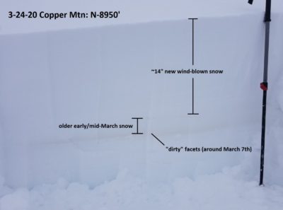
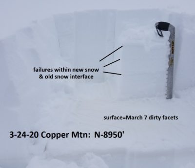
Above 8500': Isolated wind-slabs on NW-N-NE (I didn't get a look at E aspects) at and just below ridgeline. Easiest failures were thin, very soft 10-20cm slabs (4-8" thick) formed in the lower density snow from today, failing on weaknesses within the new snow. Where slabs were stiff near the summit, some cracking on slopes <32* at old/new interface.
Stability tests: N, 8950' near summit in windloaded area: CT6-12 on layers within the new snow (Q1-2) and on dirty FC layer (Q1): ECTN4, ECTN6 on the new snow instabilities and ECTN13 on the dirty facets 45cm down.
Avalanche Problems
| Problem | Location | Distribution | Sensitivity | Size | Comments |
|---|---|---|---|---|---|
 Wind Slab
|
|
Layer Depth/Date: 3-24-20: very soft 10-20cm (4-8") of lower density wind-blown snow on top of denser new snow, a few 20-35cm stiffer slabs involving the denser storm snow |
No wet loose problem today, but it's coming soon.
Terrain Use
I avoided wind-loaded starting zones and very steep, consequential lower elevation starting zones in the late afternoon.