Pro Field Report
Basic Information
Observation Details
Observation Date:
February 6, 2021Submitted:
February 6, 2021Observer:
SAC - Chris LundyZone or Region:
Galena Summit and Eastern MtnsLocation:
Prairie Peak (7000-9300', SE-E-NE)Signs of Unstable Snow
Recent Avalanches?
YesCracking?
None ExperiencedCollapsing?
None ExperiencedSnow Stability
Stability Rating:
FairConfidence in Rating:
ModerateStability Trend:
ImprovingBottom Line
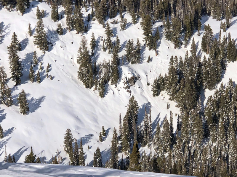
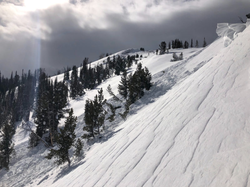
NW winds were actively loading upper elevation ridgelines. While beginning my descent, I unintentionally remotely-triggered a small(ish) wind slab avalanche. The late-January weak layer was discernible in two different snowpits about 2' deep but did not produce any results during snowpack tests.
Media/Attachments
Advanced Information
Weather Summary
Cloud Cover:
Mostly CloudyWind:
Moderate , NWNew/Recent Snowfall:
Seemed like around 5-7cm settled HN from yesterdayWinds were regularly gusting to strong. Skies around the Galena Summit area were BKN until they became OVC midafternoon. Looked sunny in the Wood River Valley. On the drive home, the Sawtooths were full socked in and there were a few snow flurries in the Sawtooth Valley.
Avalanche Observations
| # | Date | Location | Size | Type | Bed Sfc | Depth | Trigger | Photos | Details |
|---|---|---|---|---|---|---|---|---|---|
| 1 |
Feb 6, 2021 2:00 pm (Exact) |
Prairie Peak SE 9300ft |
D1 | HS-Hard Slab | 1.5ft |
AS-Skier r-Remote |
|
Report
Link |
|
| 1 |
Feb 5, 2021 (+/- 1 day) |
Galena Peak West Ridge NW 9900ft |
D2 | N-Natural | Report |
I also observed a very small natural wind slab just next to the one I triggered, as well as a D1 persistent slab in mid-elevation, sheltered terrain (see photo).
Snowpack Observations
HS at lower elevations (7000') was around 1m. 12/11 could be felt with a ski pole about 80cm down.
@7900', NE: HS 140cm. 12/11 down 105cm, still weak and dry. 1/27 down 55cm and presented as subtle FCsf. ECTX in top 90cm even with very hard hitting.
@9000, NE: HS 170cm. 12/11 seemed to be down around 110-130cm - the wind exposure of this slope may have produced variable slab depth. No tests on 12/11. 1/27 was 65cm down and was a thin layer of FCsf with small 3mm SH. ECTX (x2) even with very hard hitting. Very hard loading steps brought out a propagating result (x2) about 85cm down - maybe 1/13?
Avalanche Problems
| Problem | Location | Distribution | Sensitivity | Size | Comments |
|---|---|---|---|---|---|
 Wind Slab
|
|
Layer Depth/Date: up to 60cm Comments: Triggered wind slab... |
|||
 Persistent Slab
|
|
Layer Depth/Date: 60cm Weak Layer(s): Jan 27, 2021 (FCsf) Comments: Multiple ECTX's in two pits. Rose indicates observed terrain. |
|||
 Deep Persistent Slab
|
|
Layer Depth/Date: 80-130cm Weak Layer(s): Dec 11, 2020 (FCsf) Comments: No tests performed or new information. Rose indicates observed terrain. |
Terrain Use
I avoided avalanche terrain except for a few small/inconsequential slopes in the low 30s.