Pro Field Report
Basic Information
Observation Details
Observation Date:
February 16, 2021Submitted:
February 16, 2021Observer:
SAC - Scott Savage, Terry O'ConnorZone or Region:
Galena Summit and Eastern MtnsLocation:
Baker Ck (6700-9200': NE-E-SE-S-SW)Signs of Unstable Snow
Recent Avalanches?
YesCracking?
None ExperiencedCollapsing?
IsolatedSnow Stability
Stability Rating:
GoodConfidence in Rating:
HighStability Trend:
Bottom Line
Good stability in sheltered terrain, poor stability where wind-loaded. We saw a few sizable natural slides in generally S-E facing alpine terrain. Moderate N-NW winds were loading slopes near exposed ridgelines above about 9000'. The deeper persistent instabilities buried in December and January continue to show signs of improvement (lack of collapsing, better-looking structure, improving test scores)...but I don't trust them yet.
Media/Attachments
Advanced Information
Weather Summary
Cloud Cover:
ObscuredTemperature:
Teens and low 20s F (based on wx stations)Wind:
Moderate , NWNew/Recent Snowfall:
At 8000': 10cm overnight, 2-3cm today by 2:30 PM. Settled storm total=15-35cm in sheltered terrain depending on elevation and aspect (more settlement on solars).Snowing lightly when we left. Lots of low-density snowfall available for transport at middle elevations. At upper elevations, we saw a lot of scoured rock patches in the Smoky and Boulder Mtns when visibility allowed; winds have been moving snow up high.
Avalanche Observations
| # | Date | Location | Size | Type | Bed Sfc | Depth | Trigger | Photos | Details |
|---|---|---|---|---|---|---|---|---|---|
| 1 |
Feb 16, 2021 (+/- 1 day) |
Boulder Peak S 9800ft |
D2 | SS-Soft Slab | N-Natural | Report | |||
| 1 |
Feb 16, 2021 (+/- 1 day) |
Norton Ck SE 9300ft |
D2 | SS-Soft Slab | N-Natural | Report | |||
| 1 |
Feb 16, 2021 (+/- 1 day) |
Norton Ck - Big Lost Lake SE 9600ft |
D2 | SS-Soft Slab | N-Natural | Report |
Lots of small cornice fall and little D1 loose snow dribbles coming off the ridgelines. The crowns we could see were triggered by small slides hitting them from above.
Snowpack Observations
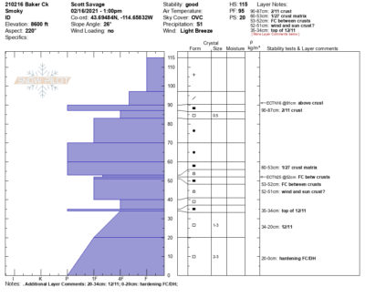
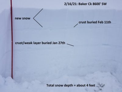
8000-8800' S-SW: HS=100-130cm with prominent crusts at 2/11 and 1/27. 12/11 is looking better. See attached photo and SnowPilot profile.
Avalanche Problems
| Problem | Location | Distribution | Sensitivity | Size | Comments |
|---|---|---|---|---|---|
 Wind Slab
|
|
Unknown |
Layer Depth/Date: 30-45cm Comments: Specific to at/near ridgelines, lee aspects from NW winds where we were. Lots of hand pits tugging and tapping and pulling on wind slabs: they were failing 12-18" down on a mid-storm layer and/or on the 2/11 interface. Wind deposits were mostly "soft" where we were. |
||
 Persistent Slab
|
|
Layer Depth/Date: 65-86cm (2-3 ft) Weak Layer(s): Jan 27, 2021 (FCsf) Dec 11, 2020 (FCsf) Comments: 12/11 looking at lot better structure wise, no bad test results...but it's still there. 1/27 looks a lot different on this SW aspect (crust matrix) - seems like it's still capable of doing something, but it probably needs a wind event or big load at middle elevations to reactivate. |
Terrain Use
We planned to avoid wind-loaded starting zones and all large, consequential avalanche paths. We did not see anything to change our plan. We skied non-consequential avalanche terrain (no terrain traps or trees in the runouts) and without wind-loading, below 35*.