Pro Field Report
Basic Information
Observation Details
Observation Date:
February 27, 2021Submitted:
February 27, 2021Observer:
SAC - Chris LundyZone or Region:
Galena Summit and Eastern MtnsLocation:
4th of July Lake (9000-9700', NW-W-SW)Signs of Unstable Snow
Recent Avalanches?
YesCracking?
None ExperiencedCollapsing?
None ExperiencedSnow Stability
Stability Rating:
FairConfidence in Rating:
ModerateStability Trend:
ImprovingBottom Line
Weak layers buried in the top 2-3' of the snowpack seem most prevalent on solar aspects. While I did not experience signs of instability, the buried weak layers combined with recent new snow and wind lead to me believe the dangerous conditions exist - primarily in wind-loaded, upper elevation terrain.
Media/Attachments
Advanced Information
Weather Summary
Cloud Cover:
Mostly CloudyTemperature:
teens F (estimated)Wind:
Light , NWNew/Recent Snowfall:
20-25cm HST since 2/25Skies were initially SCT to BKN, but squally weather in the afternoon lead to periods of OVC and a trace of new snow fell. I did not get onto any exposed ridgelines, but winds up high seem to be blowing light to moderate and were occasionally moving snow. Ski pen averaged around 20-25cm.
Avalanche Observations
| # | Date | Location | Size | Type | Bed Sfc | Depth | Trigger | Photos | Details |
|---|---|---|---|---|---|---|---|---|---|
| 7 |
Feb 26, 2021 (+/- 1 day) |
Northern Sawtooths NE ft |
D1.5 | N-Natural |
|
Report |
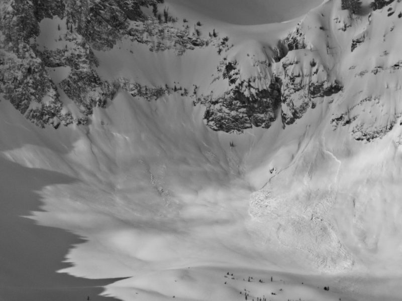
I had glassed the Sawtooths from Imogene to Goat Creek, and saw over a half-dozen slabs. Almost all released in the aprons below cliffs. I had reasonable light in the 4th of July drainage and did not see any avalanche activity.
Snowpack Observations
@9460', NW: HS 185cm. ECTX x2 in the top 130cm of the snowpack. No obvious weak layer observed. 12/11 down about 130cm.
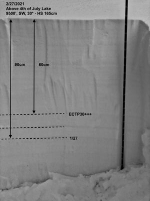
@9500', SW, 30*: HS 165cm. Three prominent PWLs observed ranging from 60-90cm down. The uppermost consisted of a thin layer of FC and produced one ECTP30+++ and one ECTX. The other two had very soft/thin crusts associated with them - much less pronounced than I've seen elsewhere - these were ECTX x2. See photo.
There were enough clouds and cold temps that solars remained cold and dry.
Avalanche Problems
| Problem | Location | Distribution | Sensitivity | Size | Comments |
|---|---|---|---|---|---|
 Persistent Slab
|
|
Layer Depth/Date: 60-90cm Comments: Rose indicates where I observed the problem. I also dug on a shady aspect, but did not see any prominent weak layers. |
I did not get into the alpine, but based on the drifting I observed at treeline and what I could see up high, I'm fairly certain there was a wind slab problem at upper elevations.
Terrain Use
I avoided avalanche terrain.