Pro Field Report
Basic Information
Observation Details
Observation Date:
December 28, 2022Submitted:
December 28, 2022Observer:
SAC - Jon Preuss (off duty)Zone or Region:
Galena Summit and Eastern MtnsLocation:
Galena Pass Roadside tour (7500-8500'; NE-S)Signs of Unstable Snow
Recent Avalanches?
YesCracking?
None ExperiencedCollapsing?
IsolatedSnow Stability
Stability Rating:
FairConfidence in Rating:
ModerateStability Trend:
SteadyBottom Line
Yesterday's furious wind damage was covered by a nice blanket of light snow. I found a widespread temperature crust at the new/old interface (12/26) that wasn't alarming and should heal quickly. The storm ended right-side up above ~7000', with a draining snowpack where rain occurred.
Advanced Information
Weather Summary
Cloud Cover:
Mostly CloudyWind:
Light , NWNew/Recent Snowfall:
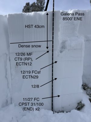
HST 43cm @8500'Sun poking through some storm clouds producing S-1 in areas. I was mainly out of NW winds, but could feel a couple of light gusts from that direction. There is PLENTY of fresh snow to get pushed around out there.
Avalanche Observations
| # | Date | Location | Size | Type | Bed Sfc | Depth | Trigger | Comments | Photo |
|---|---|---|---|---|---|---|---|---|---|
| 5 |
Tornak Hut Approach (nearby) NE 7800' |
D1.5 | SS | 2-3' | N-Natural | Gauging on the depth, I would guess this failed on the 12/19 layer. There are another 3 similar looking slides on the next slope to the east. |
|
I could barely make out another crown in the Boulders but clouds were moving through the range.
Snowpack Observations
The snowpack painted the story of the last 48 hours. The above normal mountain temperatures on Dec. 26 created a varying thickness of a melt freeze crust (razor thin to 2cm). When the storm started on the morning of 12/27, temperatures hovered slightly above freezing. That created the perfect environment for hot pow (moist snow) during the onset of the storm.
In lower elevations, there was a 5cm of moist new snow glued onto the new/old interface of 12/26. As the temperatures continued to drop towards the end of the daylight hours, the new snow fell with the light powdery density that dreams are made of. The new snow depths varied from 17cm @7500' to 43cm @8500'. There was a density change down 29cm from the surface with CT9 (RP) on that layer. There were no persistent grains at this layer.
The lower persistent layers weren't talkative in my 8500' ENE snow pit. The only notable tests were CPST 31/100 (END) x2 dn 100cm on the 11/27. The layer presented as 5cm of rounding facets (2mm) with F+ resistance.
Avalanche Problems
| Problem | Location | Distribution | Sensitivity | Size | Comments |
|---|---|---|---|---|---|
 Persistent Slab
|
|
Layer Depth/Date: 100cm/1127 Weak Layer(s): Nov 27, 2022 (FC) Comments: Rose colored by what I observed in the snowpack. |