Pro Field Report
Basic Information
Observation Details
Observation Date:
December 27, 2019Submitted:
December 27, 2019Observer:
SAC - Lundy (off duty), BudgeZone or Region:
Sawtooth and Western Smoky MtnsLocation:
E Fork Valley Creek (NW of Stanley)Signs of Unstable Snow
Recent Avalanches?
None ObservedCracking?
None ExperiencedCollapsing?
IsolatedSnow Stability
Stability Rating:
FairConfidence in Rating:
HighStability Trend:
SteadyBottom Line
Surprise! Surface hoar layer exists in this area as well about 18-24 inches down. Snowpit looked very similar to Ethan's 12/25 Soldiers pit 60 miles away.
Advanced Information
Weather Summary
Cloud Cover:
OvercastTemperature:
n/oWind:
Light , NWSkies started out scattered but became overcast to obscured by late afternoon. Snowflakes (or aerial surface hoar?) flurried down at times. Cold.
Snowpack Observations
Most snowpack obs were from 7800-8900', NW-W-SW aspects. Solar aspects in this elevation range were thin, HS was around 40cm. Shadier W had depths ranging from 50-90cm, decreasing with elevation.
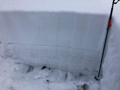
Pit @8600', NW:
Depth was 90cm, which seemed a bit deep—adjacent areas seemed to average more like 60-80cm. 12/7 was down 50cm with a 4F slab above. Basal/October DH was more pronounced than expected, with the familiar 30cm of F DH, topped with a 1cm P MF crust, with 2cm of FC above the crust. Performed two ECTs, they both propagated with moderate and hard taps in facets above and below the MF crust. No failures in the 12/7 SH in ECTs, however it produced a PST 37/100end.
As you dropped below around 8000' (bottom end of mid elevation) on W aspects, the snowpack became much shallower, weaker, and lacked slab properties.

Avalanche Problems
| Problem | Location | Distribution | Sensitivity | Size | Comments |
|---|---|---|---|---|---|
 Persistent Slab
|
|
Layer Depth/Date: 40-60cm - 11/26 and 12/7 |
Terrain Use
We avoided avalanche terrain. While ascending, our route was taking us to a spot where we were going to be beneath a slope in the low to mid 30s. Once we recognized this, we chose to backtrack and found a lower angle route.