Pro Field Report
Basic Information
Observation Details
Observation Date:
March 9, 2020Submitted:
March 9, 2020Observer:
SAC - SavageZone or Region:
Galena Summit and Eastern MtnsLocation:
Boulder Mtns: Spring-Cherry Creek to 10,000'Signs of Unstable Snow
Recent Avalanches?
YesCracking?
None ExperiencedCollapsing?
None ExperiencedSnow Stability
Stability Rating:
GoodConfidence in Rating:
HighStability Trend:
Bottom Line
Very isolated, small wind slabs in alpine terrain were easy to spot today. Mid-elevation west aspects (snowpack= about 2 ft or 60 cm) were becoming unsupportable late afternoon and will probably have wet avalanche issues in the coming days.
Advanced Information
Weather Summary
Cloud Cover:
Partly CloudyTemperature:
Near 20 F up high, 30s F at roadWind:
Light , WVariable clouds from partly to mostly cloudy, some snow flurries. Wind was light to moderate, moving some snow over ridges but not really loading anything.
Avalanche Observations
| # | Date | Location | Size | Type | Bed Sfc | Depth | Trigger | Comments | Photo |
|---|---|---|---|---|---|---|---|---|---|
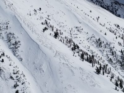
| 1 |
Cerro Ciento main W/SW ridge N Alpine, near 9800' |
D1 | SS | I-New/Old Interface | N-Natural | Steep, cross-loaded gully. It failed on a N/NW aspect in a NW facing gully. |
|
Snowpack Observations
Alpine terrain: The 1-3" of new snow from the past couple days was moved around a bit by the wind. It stayed cool today with cloud cover+breeze+temps near 20 F. What you see is what you get.
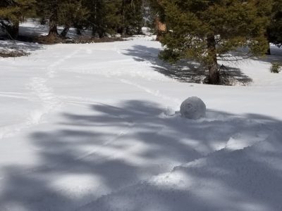
Middle elevations: The surface on due S, open slopes, was trying to become corn with a good freeze on crusts below the new snow. On W aspects, the shallow snowpack went from supportable with dust on crust to moist throughout and barely supportable during the afternoon, especially in sparse trees. Ski turns were creating nice "snails" in ~25 degree terrain (see photo). Open, SW and W facing terrain had a stouter crust/better freeze and stayed supportable more than slopes with even sparse trees.
Avalanche Problems
Wind slab: D1-1.5 in alpine terrain but very isolated distribution and easily avoided/managed.
Wet loose: Today, this wasn't a full-blown problem. But, there is potential for full depth wet loose slides in the coming days, mainly on the eastern and western thirds of the compass below about 9000' where the snowpack is shallow.
Terrain Use
I planned to avoid steep, wind-loaded slopes but did not encounter any. I would not have skied steep west aspects late this afternoon (possible wet loose issues as well as knee preservation).