Pro Field Report
Basic Information
Observation Details
Observation Date:
March 18, 2020Submitted:
March 18, 2020Observer:
SAC - SavageZone or Region:
Galena Summit and Eastern MtnsLocation:
Baker Ck/Brodie Gulch: 6650-9300', most aspectsSigns of Unstable Snow
Recent Avalanches?
None ObservedCracking?
None ExperiencedCollapsing?
None ExperiencedSnow Stability
Stability Rating:
GoodConfidence in Rating:
ModerateStability Trend:
Bottom Line
The recent storm (about 4-8" of new snow at middle and upper elevations near Baker Lake) is tipping us away from the simple "what you see is what you get" scenario and moving towards a persistent slab problem in specific places - the weak facets that formed in February and early March are 12-18" below the surface in places and need to be considered. Where we traveled today, I was leery of slopes steeper than about 35 degrees that had stiff, wind-transported snow since March 7th. I found this snowpack setup at and immediately below exposed ridgelines over 9000' on E-NE-N-NW aspects where I traveled. More southerly aspects had a very hard crust below the new snow and were still managed by the "what you see is what you get" mindset. With full sun expected tomorrow and Friday, the southerly aspects will probably have wet loose issues.
Media/Attachments
Advanced Information
Weather Summary
Cloud Cover:
Mostly CloudyTemperature:
20s F (above 8000')Wind:
Light , SW2" new snow at Baker Ck parking lot, about 6" new snow at summer trailhead/bathroom by Baker Lake, 8" near the ridge between Baker Ck and Brodie Gulch. Variable cloud cover ranging from overcast to partly cloudy. Winds were gusting to moderate and moving a tiny amount of snow today. W-S-E aspects below 9300' were affected by solar radiation/heat; on these slopes, winds will need to increase significantly to transport snow.
Snowpack Observations
W-SE-S-SE aspects: the new snow was moist by 3 PM and will have a crust tomorrow. On these solar aspects, there was a substantial knife-hard crust below the new snow above about 8200'. Below 8200', the crust wasn't as hard and will become unsupportable more quickly in the coming days.
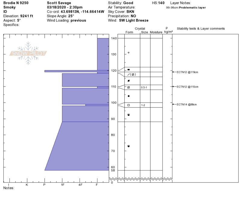
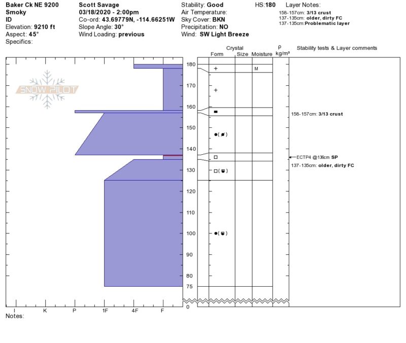
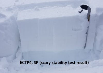
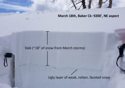
Steeper shady aspects stayed dry. Heavily wind-loaded pit/stability test location on NE aspect at ridgeline was concerning (see photos below and profile above).
Avalanche Problems
| Problem | Location | Distribution | Sensitivity | Size | Comments |
|---|---|---|---|---|---|
 Wind Slab
|
|
Unknown |
Layer Depth/Date: ~45cm (18"): buried March 7 Comments: Could call it a wind slab or persistent slab, trending towards a persistent slab. It appears to need a stiffer slab (1F and P) above well-developed facets (most prominent on E-NE-N-NW aspects). I saw this setup at the border between middle and upper elevations, but in terrain better described by "upper elevation" (exposed ridgelines). The problem was ugliest on a NE aspect, and the structure/stability changed quickly as you moved N or E from that specific aspect. |
Terrain Use
We closed wind-loaded slopes steeper than about 35* where there were facets buried over 30cm deep (E-NE-N-NW aspects near and above 9000').