Basic Information
Observation Details
Observation Date:
March 20, 2020Submitted:
March 20, 2020Observer:
SAC - LundyZone or Region:
Galena Summit and Eastern MtnsLocation:
ButterfieldSigns of Unstable Snow
Recent Avalanches?
None ObservedCracking?
None ExperiencedCollapsing?
None ExperiencedSnow Stability
Stability Rating:
GoodConfidence in Rating:
HighStability Trend:
ImprovingBottom Line
Weak, faceted snow from the February dry spell is more pronounced and widespread here compared to the Galena Summit area. However it is either not weak enough, or there is not a thick enough slab, to cause widespread instability. Still, these layers bear watching if we get additional load early next week. I did not see any wind slabs, and wet loose did not become an issue today.
Advanced Information
Weather Summary
Cloud Cover:
OvercastWind:
Light , NWThere was a trace of new snow overnight. Today's weather forecast did not play out. There were more clouds than forecast right off the bat, and after around noon it was primarily OVC with a few minor sunny breaks. Squalls came through periodically and the higher peaks were occasionally socked in. There were a few snow flurries this afternoon. Overall, temps felt fairly cool.
Avalanche Observations
The light was poor
Snowpack Observations
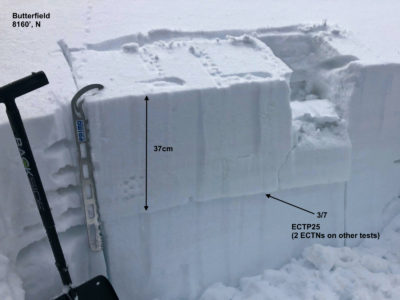
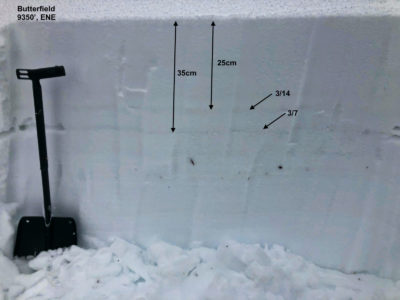
Through pole pokes, hand pits, and a couple real pits, it seems that the early March facet layers are more common here on mid and upper elevation shady slopes than what I saw yesterday on Titus. Although the layering feels suspect, either the facet layer isn't that weak, or more likely, there isn't enough of a slab. I got one ECTP on a mid-elevation, N aspect, but all other ECTs gave non-propagating results.
It seems that the weakest facet layer is about 35cm down and was likely buried 3/7. The 3/14 interface was down around 25cm and this also gave ECTNs.
HS at mid to upper elevations ranged from about 100 to 170cm.
Lower elevations and all aspects from E-S-W were in some state of melt-freeze. Solars stayed supportable on skis, even at low elevations, until at least 1500 when I exited the field.


Avalanche Problems
No problems observed. I did not see any wind slabs at the summit, and the wet loose never became an issue.
