Pro Field Report
Basic Information
Observation Details
Observation Date:
March 26, 2020Submitted:
March 26, 2020Observer:
SAC - LundyZone or Region:
Sawtooth and Western Smoky MtnsLocation:
Williams Peak AreaSigns of Unstable Snow
Recent Avalanches?
YesCracking?
IsolatedCollapsing?
None ExperiencedSnow Stability
Stability Rating:
FairConfidence in Rating:
HighStability Trend:
WorseningBottom Line
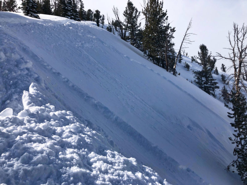
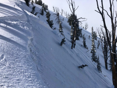
With 16 inches of new snow at upper elevations in the northern Sawtooths and gusty winds, wind slabs were common and touchy on upper elevation ridgelines. While these were generally small, I would not have felt comfortable traveling in any steep, alpine terrain. Sheltered, mid-elevation slopes had better stability. There is a lot of snow hanging on steep slopes—I would expect significant wet slide issues when the sun comes out.
Media/Attachments
Advanced Information
Weather Summary
Cloud Cover:
ObscuredWind:
Moderate , S
Storm totals ranged from around 10cm at the valley bottom, to 25cm at the hut elevation (around 8000'), to 40cm+ above 8500'. Snow was right side up and low density at the surface. There was some evidence of afternoon sun from Tuesday, as there was a moist layer in the middle of the storm snow on solar slopes.
Had a brief sunny period in the morning, but that quickly gave way to intermittent squally weather the rest of the day. There were brief periods of S1-2 snowfall, with perhaps 2-3cm of accumulation through the day. While the winds were MOD on average, they frequently gusted higher and were moving significant amounts of snow. Temps were cool to cold up high, with wind and driving snowfall I was bundled up at times.
Avalanche Observations
| # | Date | Location | Size | Type | Bed Sfc | Depth | Trigger | Comments | Photo |
|---|---|---|---|---|---|---|---|---|---|
| 5 |
Skiers Summit ridgeline (KB's, Marshall Slide) NE 9300 |
D1 | SS | S-New Snow | 20-40cm |
AS-Skier c-Intentional |
4 of these slides were triggered by ski cuts, one was remotely triggered (barely) from a ridgeline while stomping around on the ascent. They were relatively thin and needed a slope around 40*. Once started, they ran fast in the low density snow and entrained additional snow. |
|
Also saw a number of small loose snow avalanches on slopes approaching 45 degrees. These were on shady slopes so suspect they were dry loose that ran at the end of the storm.
Snowpack Observations
As mentioned in the weather section, the HST on solar slopes had a moist layer in the middle—so they likely took some brief sun at some point on Tuesday. This made for funky ski conditions on anything more solar than E. HST seemed well bonded to underlying crusts, which were frozen from the valley floor on up.
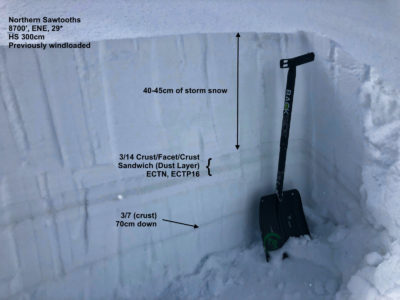
@8700', ENE (see photo): Storm snow sat atop a soft crust-facet-hard crust sandwich (3/14 layer, consisting of some dirty snow). I had one ECTN and an ECTP16 breaking in the facets between the crusts. This layering looked a bit concerning, but there didn't seem to be enough slab/load. Wasn't able to find a safe location for a more due-N aspect pit.
Avalanche Problems
| Problem | Location | Distribution | Sensitivity | Size | Comments |
|---|---|---|---|---|---|
 Wind Slab
|
|
Layer Depth/Date: 20-40cm/today Comments: Touch, fresh wind slabs at upper elevations. I found them primarily on N and NE lee ridgelines, but would expect a more widespread distribution in the alpine. |
Terrain Use
I made conservative choices due to solo travel and being extra careful due to COVID. I would not have felt comfortable in steep, alpine terrain regardless given the wind slab problem and new snow.