Pro Field Report
Basic Information
Observation Details
Observation Date:
December 28, 2020Submitted:
December 28, 2020Observer:
SAC - Savage, O'ConnorZone or Region:
Galena Summit and Eastern MtnsLocation:
Baker Ck (6600-9100', most aspects)Signs of Unstable Snow
Recent Avalanches?
YesCracking?
IsolatedCollapsing?
WidespreadSnow Stability
Stability Rating:
FairConfidence in Rating:
ModerateStability Trend:
ImprovingBottom Line
Terrible snowpack structure (soft slab over well developed facets buried on Dec 11th) + widespread collapsing + poor stability test scores = a lot of uncertainty and a chance of remotely triggering avalanches. The snowpack is adjusting to the load from the past couple weeks of snowfall, and the slab is only about a foot thick in this area. BUT, we didn't trust it and traveled very conservatively - especially in areas where the wind had stiffened layers in the upper foot of the snowpack at all. SW and S aspects had a better looking snowpack, and we didn't experience any collapsing or signs of instability on these aspects.
Advanced Information
Weather Summary
Cloud Cover:
Mostly SunnyTemperature:
single digits and teens F?Wind:
CalmSome light wind on the ridgetops around 9000', but about as calm as it gets for this area. Some evidence of isolated wind loading during and immediately after the last storm.
Snowpack Observations
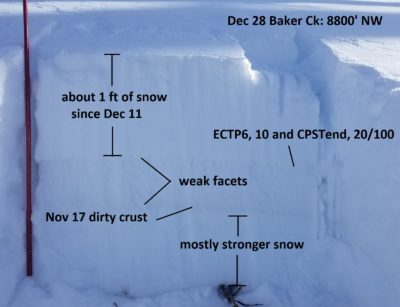
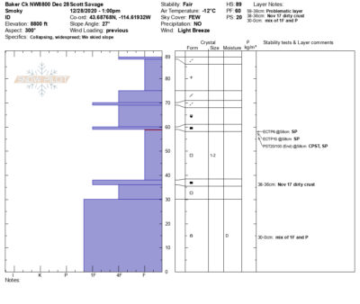
50-90cm snowpack depth. As expected, lots of weak faceted snow in the middle of the pack on shadier aspects (W-N-E-SE). On sunnier slopes (just south of due W-SW-S), stout crusts in the middle and lower pack. See SnowPilot profile and photo.
Avalanche Problems
| Problem | Location | Distribution | Sensitivity | Size | Comments |
|---|---|---|---|---|---|
 Persistent Slab
|
|
Layer Depth/Date: 20-35cm Weak Layer(s): Dec 11, 2020 (FCsf) Comments: Guessing a bit on sensitivity, probably reactive but trending towards stubborn. Problem most concerning on shady slopes 8000-9000' where weak layer was very well developed and wind had stiffened the snow above the weak layer. |
Terrain Use
We stayed out of all large avalanche paths, all starting zones over 35*, and alll wind-loaded starting zones. We were conservative going into the day, and we didn't see anything to change our minds.