Pro Field Report
Basic Information
Observation Details
Observation Date:
March 17, 2021Submitted:
March 17, 2021Observer:
SAC - Scott SavageZone or Region:
Banner SummitLocation:
Copper and Banner Summit area (6900-8300': N-W-S-SE)Signs of Unstable Snow
Recent Avalanches?
YesCracking?
None ExperiencedCollapsing?
None ExperiencedSnow Stability
Stability Rating:
GoodConfidence in Rating:
Stability Trend:
Bottom Line
Lower and middle elevation slopes facing the sun (W-SE-S-SE) became mush/glop by 3 PM, and very steep slopes would have been suspect for triggering wet loose avalanches. A nice southerly breeze and cloud cover kept exposed upper elevation slopes in this area cool enough for good skiing+riding conditions (corn) and minimal wet avalanche hazard today (as of 3 PM). Brief observations of northerly lower elevation slopes indicated they were staying cool and did not pose wet snow hazards.
Advanced Information
Weather Summary
Cloud Cover:
Mostly CloudyTemperature:
40s FWind:
Light , SNew/Recent Snowfall:
None.Sky was clear in the AM, increasing clouds all day, mostly cloudy with some flurries and graupel by 3 PM. Temps were low 40s F at Banner Summit on the road, 30s F at middle elevations. Wind was steady light, gusting to moderate speeds.
Avalanche Observations
| # | Date | Location | Size | Type | Bed Sfc | Depth | Trigger | Comments | Photo |
|---|---|---|---|---|---|---|---|---|---|
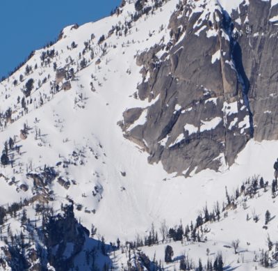
| 1 |
McGown Peak E 9100 |
D1.5 | WL | N-Natural | Also a fresh D1 to looker's right of the bigger slide. |
|
|||
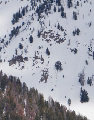
| 1 |
Gladiator Ck W 9100 |
D1 | WL | N-Natural | Several generations of WL in this area, seemed like one or 2 were quite fresh. |
|
Its getting hard to tell how fresh or old various wet avalanches are.
Snowpack Observations
HS Copper 6900-8300=110-180 cm.
W-SW-S-SE got sloppy (top 20cm, suction cup skiing) in wind-sheltered terrain below about 7800' by 3 PM. Sun-exposed lower elevation slopes below about 7500' were getting spooky - falling a little deeper into the snowpack on skis in isolated spots.
Shady aspects did not have wet issues today. Upper elevation S aspects stayed cool enough (nice supportable corn) by 3 PM, probably because of the steady breeze.
Terrain Use
We avoided W-SW-S-SE facing avalanche terrain below about 7800' once the surface softened significantly. We also stayed out of the northerly >38* terrain just above the highway (don't trust it given that it piles into a creek...).