Pro Field Report
Basic Information
Observation Details
Observation Date:
December 21, 2021Submitted:
December 21, 2021Observer:
SAC - DavisZone or Region:
Soldier and Wood River Valley MtnsLocation:
Wells SummitSigns of Unstable Snow
Recent Avalanches?
None ObservedCracking?
IsolatedCollapsing?
IsolatedSnow Stability
Stability Rating:
FairConfidence in Rating:
LowStability Trend:
SteadyBottom Line
Where old snow (prior to December 11th) exists, I experienced collapsing and observed unstable snowpack test results. I would not have skied similar 35* slopes. Old snow extent may be broader in distribution than in the WRV as I suspect it extends to lower elevations. Given the structure, test scores, and collapsing I'd expect natural avalanche activity with a decent load of new snow later this week.
Media/Attachments

Advanced Information
Weather Summary
Cloud Cover:
ClearTemperature:
0-25FWind:
Light , WNew/Recent Snowfall:
10 cm HST (12/19)0F in Fairfield and 18F at Wells Summit TH. Light W wind, no blowing snow. High clouds increased late in the afternoon.
Avalanche Observations
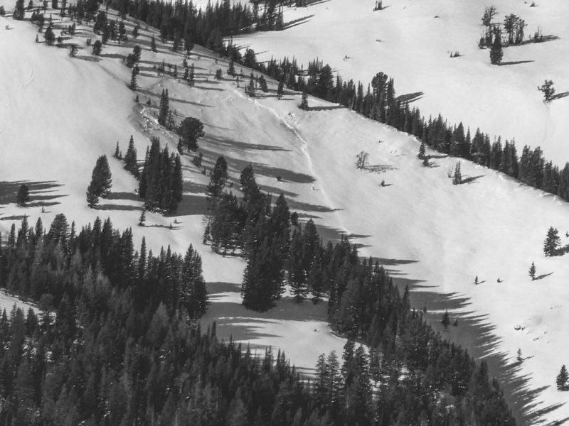
The only avalanches I could make out with any certainty are those in the images below. I sat and glassed for quite some time, took photos, and looked closely at them on the computer. I feel that I would have seen a slide similar to the one on Peak 2, as that crown was still easily visible. That said, it's been windy, snowing and it was a multi-day storm, so I'm sure there were slides that went undetected.
Snowpack Observations
The snowpack depth in this area is sufficient to cover sage and rocks beginning at about 8,000' (a little lower on shaded aspects). Based on limited obs, it looks like old snow exists lower in elevation on shadies here than in the WRV. The 12/11 storm did not produce as much snow here as compared to the WRV with slabs ranging from 20-45 cm (sunny-shaded) at 8,000'.
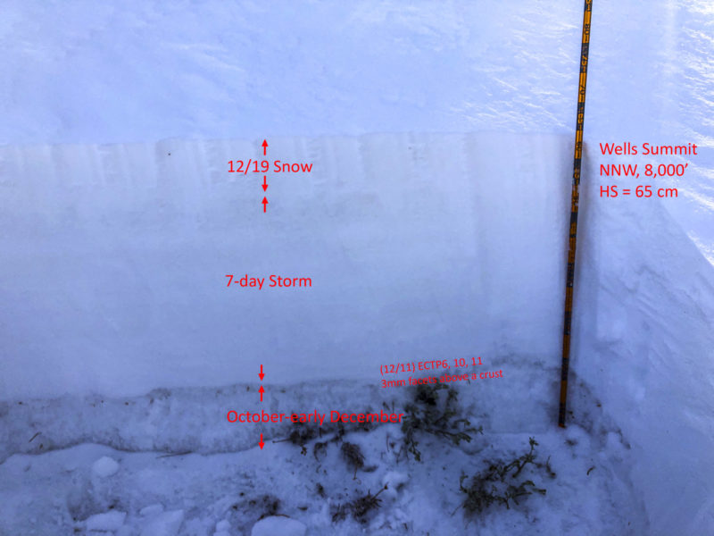
Pit image and test results can be seen in the image. Generally a soft F-4F slab sits on the ground or old snow (3mm FC above a crust). Where old snow exists I got unstable snowpack test scores and experienced collapsing.
There were very few off-trail tracks except near the Corrals and NE of Wells Summit in areas that are generally open, smooth, and heavily traveled. We're one good storm away from widespread off-trail riding.
Avalanche Problems
| Problem | Location | Distribution | Sensitivity | Size | Comments |
|---|---|---|---|---|---|
 Persistent Slab
|
|
Layer Depth/Date: 40-60 cm Weak Layer(s): Dec 11, 2021 (FC) Comments: Estimated for the Soldiers based on early season snow and limited obs. |
I encountered 1' drifts from recent (12/19) snow and wind. These were confined to the upper 40' of ridgetops. I'd imagine you'd encounter more of these at upper elevation.
Terrain Use
I would have felt comfortable in avalanche terrain lacking snow prior to 12/11. I planned to avoid avalanche terrain where old snow existed and happily stuck to that plan.