Pro Field Report
Basic Information
Observation Details
Observation Date:
January 7, 2022Submitted:
January 7, 2022Observer:
SAC - Chris LundyZone or Region:
Galena Summit and Eastern MtnsLocation:
Titus Ridge (8700-9900', SE-E-NE)Signs of Unstable Snow
Recent Avalanches?
YesCracking?
None ExperiencedCollapsing?
None ExperiencedSnow Stability
Stability Rating:
FairConfidence in Rating:
ModerateStability Trend:
ImprovingBottom Line
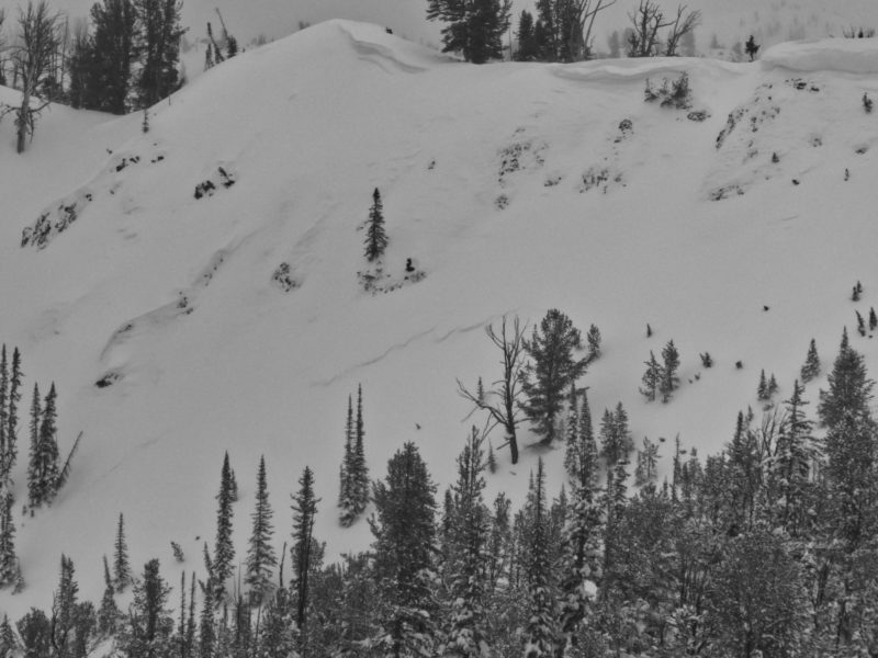
The storm's on its way out, but it was still going today. More snowfall and strong winds continue to load the snowpack. Settled storm totals since 1/3 on Titus Ridge are hard to pin down, but best guess puts them in the 2-2.5' range. Significant wind loading has taken place over the past few days, and large amounts of snow were being transported today forming new wind slabs. The loading is also adding weight to the October snow, which in the pit I dug, was over 4' down but still looked surprisingly weak. Best approach is to keep it simple and let the dust settle from the storm.
Media/Attachments
Advanced Information
Weather Summary
Cloud Cover:
ObscuredWind:
Strong , NWNew/Recent Snowfall:
Best guess on settled HST since 1/3 is around 60-70cmHad S2-3 late morning, then the snowfall tapered to S1 - S-1 as the cold front moved in. Winds were strong, gusty, and moving large quantities of snow (see video).
Avalanche Observations
I did not see any new slides. I had enough visibility that I would have seen slides similar to the one Savage reported yesterday in the terrain above Titus Lake. The light was flat enough I may have missed small/thin storm slabs. Unfortunately, the wind was obscuring the view towards Weather Station Peak so I did not get a great look at that terrain.
Snowpack Observations
Density changes within the HST could be felt with a ski pole, but there was nothing remarkable in hand pits, stepping above the skin track, or in the pit below.
@9200', E, 28*: HS 185cm. 12/11 down 140cm, facets (2-3mm) were still fairly weak (4F) and concerning. Slab above is P for the bottom ~ 40cm. There was little layering above 12/11 - I could make out what may have been the 1/3 interface down around 70cm. Unremarkable ECTNs in the M to H range within the top 100cm. No tests performed on 12/11.
Avalanche Problems
| Problem | Location | Distribution | Sensitivity | Size | Comments |
|---|---|---|---|---|---|
 Wind Slab
|
|
Comments: I watched fresh wind slabs form atop previous generations of wind slabs from the past few days. The multiple generations were meaty enough that I didn't feel comfortable stomping in many places where it was steep enough to get things to move. The fresh wind slabs didn't seem particularly touchy, but I wouldn't have touched a wind loaded slope. |
|||
 Deep Persistent Slab
|
|
Layer Depth/Date: 140cm Weak Layer(s): Dec 11, 2021 (FC) Comments: Rose shaded on where I observed it. 12/11 still looks concerning, and is trending towards a legit deep slab problem. Likely less deeply buried in portions of this zone that received less recent snowfall. |
Terrain Use
I avoided avalanche terrain