Pro Field Report
Basic Information
Observation Details
Observation Date:
January 25, 2022Submitted:
January 26, 2022Observer:
SAC - VandenBosZone or Region:
Galena Summit and Eastern MtnsLocation:
Camp Creek (8,250-9,000', primarily W-NW-N)Signs of Unstable Snow
Recent Avalanches?
None ObservedCracking?
None ExperiencedCollapsing?
None ExperiencedBottom Line
The likelihood of triggering a large avalanche involving October snow has decreased significantly, but the snowpack structure continues to be worrisome. The weak layer+slab combination has found a mostly "comfortable" conformation... for the time being. However, there are still plenty of places in this zone that I would choose not to go.
Advanced Information
Weather Summary
Cloud Cover:
ClearWind:
Light , NNew/Recent Snowfall:
3cm HN24, 10-12m HN since 1/20Much colder day than many of the past few weeks.
Avalanche Observations
No recent avalanches observed.
Snowpack Observations
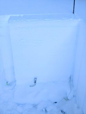
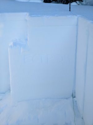
My primary objective was to look at the 12/11 ("October snow") weak layer and the overlying slab in the vicinity of Galena Summit. I dug at 8,700' on a NW aspect above Camp Creek on the Salmon side of the pass. Here, 12/11 was buried 115-120cm down beneath an impressively stiff slab of snow. This slab quickly stiffened from F at the top to K at the base. The upper portion of the 12/11 interface was adhered to the base of the slab, but immediately below this (and sandwiched between the slab and an icy crust was an interval of 4F to 4F+ depth hoar grains. These grains were showing some signs of rounding (some striations flattened off cups, some edges rounded off cups), but the snowpack structure continues to be worrisome. This weak layer continued to produce some concerning snowpack test scores: ECTP24, ECTN (even with 10 extra hulk smahses) ECTP29, and CPST 42/120 END x2. I think the combination of slab stiffness and time since significant loading make triggering an avalanche involving this snow unlikely, but I still have no interest in testing that theory with my skis or machine. I expect that we have not seen the last avalanche involving 12/11 in areas where it looks like what I found today.
My secondary objective was to look at the current snow surface and to look for the presence of SH at the 1/20 interface. I found large (up to 1cm) standing SH at 1/20 with plenty of airspace in between the individual crystals. The snow above and below this was well-faceted. The upper 15-20cm of the snowpack is likely to produce problems when snowfall returns.
Avalanche Problems
| Problem | Location | Distribution | Sensitivity | Size | Comments |
|---|---|---|---|---|---|
 Persistent Slab
|
|
Weak Layer(s):
Dec 11, 2021 (FC)
Comments: Rose shaded based on where problem is known to exist. |
I did not encounter a wind slab problem today, but I did not go looking for one either.
Terrain Use
I suspect you could go most places without triggering a large avalanche involving the October snow. But the lingering possibility, regardless of how unlikely, continues to keep me out of steep, rocky, upper elevation terrain where this snow exists at the base of the snowpack.