Basic Information
Observation Details
Observation Date:
March 6, 2022Submitted:
March 6, 2022Observer:
SAC - VandenBosZone or Region:
Galena Summit and Eastern MtnsLocation:
Headwaters to Smoky crest (7,400-10,300', primarily SE-S-SW-W-NW)Signs of Unstable Snow
Recent Avalanches?
None ObservedCracking?
IsolatedCollapsing?
IsolatedSnow Stability
Stability Rating:
GoodConfidence in Rating:
ModerateStability Trend:
SteadyBottom Line
The persistent slab problem is beginning to rear its head.
Media/Attachments
Advanced Information
Weather Summary
Cloud Cover:
Partly CloudyWind:
Light , NENew/Recent Snowfall:
1cmDay started mostly sunny, with high stratocumulus moving into the Sawtooths by mid-morning. Clear in the Smokys and southern Sawtooths when I left the truck around 1100, with clouds building into the early afternoon from the E/NE. Convective cloud deck brought snowfall and increasing wind speeds to the Smokys around 1400. Periods of S-1 to S1 precip and gusty moderate winds. Winds were generally calm to light before the clouds rolled in. Kind of a spring-time vibe out there. 1cm of new snow from pervious day's storm. Trace of new from today's showers.
Avalanche Observations
I observed many small loose wet avalanches from the rain and warm temperatures at the beginning of the week.
Snowpack Observations
Goals were to check in on the budding persistent problem in this area, check amount of new snow and amount of wind transport, and look at rain line.
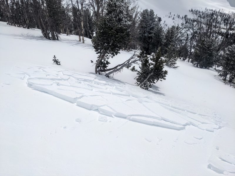
New snow+wind: I found some very small, but reactive wind slabs in upper elevation terrain in this area. Based on their distribution these were built during the past 24 hours, when wind speeds picked up and shifted to the N/NE. These slabs were reactive even where they were less than 5cm thick. The thickest wind slab I encountered was 15cm thick, and it produced cracks that extended a few meters from my skis and a few meters downslope (where the slab ended). Based on the size of these, you would really have to go looking to have a problem with them, and would need some steep, high consequence terrain.
Rain: It had rained up to at least 9,000' where I was, with the rain crust grading into a wet snow/slush crust up to 9,500' or so.
Persistent slabs: I dug on a sheltered N/NW aspect at 9,300'. I found a 24-28cm thick slab of snow overlying the 1/20 interface. This produced consistently unstable test scores with easy force (ECTP 6, 8, 7). The slab ranged from 4F to F hard and included a prominent dust layer 15-20cm down (buried on V-day?). The failure surface was 2-3mm FCsf with a few SH grains to 8mm sprinkled in. More of a FCsf problem, I don't think the SH was contributing to instability. These results, in conjunction with other observations, the nearby avalanche reported in the N bowl of Saviers Peak, and the avalanche activity in the Banner Summit area (where the slab is a bit thicker), point to a clear pattern: we've got widespread weak layers buried, just a matter of putting enough of a slab on top. It doesn't seem like it will take much.
Current surface: The combination of the rain crust plus a cm of new snow on top could make for a problematic layer at lower and middle elevations. It was hard to tell if the new snow was faceting already, but I'd anticipate it is headed in that direction. At upper elevation the wind was probably muting the effect of (faceting?) new snow, but there are plenty of slick crusts and such.
Avalanche Problems
I did not directly encounter any avalanche problems today. Wind slabs would have been problematic in higher consequence terrain or where they were thicker (not sure they are thicker anywhere). The persistent slab problem isn't quite there yet, or it wasn't for me. But it is darn close.
Terrain Use
I was mindful of recently deposited wind slabs in my travels. I was also aware of areas where older slabs might have been built on top. Primary hazards were posed by challenging skiing conditions.


