Pro Field Report
Basic Information
Observation Details
Observation Date:
March 29, 2022Submitted:
March 29, 2022Observer:
SAC - DavisZone or Region:
Galena Summit and Eastern MtnsLocation:
Baker/Brodie Divide (All but W, 6,700-9,700')Signs of Unstable Snow
Recent Avalanches?
None ObservedCracking?
None ExperiencedCollapsing?
None ExperiencedSnow Stability
Stability Rating:
GoodConfidence in Rating:
ModerateStability Trend:
SteadyBottom Line
The snowpack is draining/refreezing at a slow rate. Crusts broke down and I was skiing slop by midday on steep, sunny slopes. A good solid clear, cold night will dramatically change this picture moving forward. Dry, slab avalanches seemed unlikely.
Media/Attachments

Advanced Information
Weather Summary
Cloud Cover:
Partly CloudyTemperature:
Upper 30s FWind:
Moderate , NESome light rain this morning near the SNRA. A thick cap of clouds on the Boulders, likely lightly raining fairly high given the temps. I didn't see any accumulation (in the trees) at any point. Moderate wind from the N and NE. Hot in the sun but wind kept it bareable. No snow moving.
Snowpack Observations
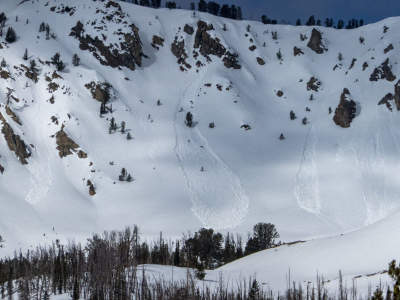
I went back to the area where riders triggered a persistent slab above Brodie (Baker Ck Drainage) on March 18th to see how the persistent weak layer here fared during the heatwave.
Overall Impression: My sense is that triggering a slide in this same sort of terrain is unlikely, even where the weak layer stayed dry. I think we're talking about a very limited chunk of terrain where this might still pose an issue, namely very steep slopes >9,500' that face NNW-N-NNE. Even here the slab has sat for 10 days and is faceting.
NNE @ 9,500-9,700': The weak layer was still preserved, dry, and weak (fist facets). I imagine it's similarly weak on N and NNW as well. The slab is ~35 cm thick and faceting (4F). Snowpack tests showed propagation ECTP around 10 taps but I couldn't get any cracking when stomping around above the pit.
ENE (70 deg) slope @ 9,500': Immediately adjacent to these pit results above, I found moist/wet snow and large percolation columns (to full arm depth). Anything with a kiss of sun was pushing lots of water through the weak layer.
Avalanche Problems
| Problem | Location | Distribution | Sensitivity | Size | Comments |
|---|---|---|---|---|---|
 Wet Loose
|
|
Comments: Shaded where observed + expected. There was a decent corn window on S and SW before ~11 AM. Anything facing the sun was getting mushy/punchy after that. There is still a lot of water sitting in the snowpack. Crusts were 10-20 cm thick (open sky view) but breaking down by midday with glop underneath. Wind helped keep things a little cooler at upper elevations. |
|||
 Persistent Slab
|
|
Comments: ECTP10 down 35 on FC, NNE @ 9,700' |
Terrain Use
I would have avoided very steep terrain on NNW-N-NNE greater than about 9,400' given the poor snowpack structure. The weak freeze was worse than I expected. I would have avoided classic, sunny, wet loose terrain in the afternoon.