Pro Field Report
Basic Information
Observation Details
Observation Date:
April 16, 2022Submitted:
April 17, 2022Observer:
SAC - Scott Savage (short rec tour - OFF DUTY)Zone or Region:
Galena Summit and Eastern MtnsLocation:
Galena Summit - Cross (8300-9200': NW-N-NE-E-E-SE)Signs of Unstable Snow
Recent Avalanches?
None ObservedCracking?
None ExperiencedCollapsing?
None ExperiencedSnow Stability
Stability Rating:
GoodConfidence in Rating:
LowStability Trend:
Bottom Line
Lots of wind + drifting + dunes/surface ripples and waves in middle elevation terrain, but no wind slabs where I traveled. Alpine winds were strong today, exposing lots of rock in the Boulder Mtns and still pluming snow off higher peaks in the Smoky Mtns at 5 PM. I saw some rollerballs on roadside paths near and below Galena Lodge, but no wet loose slides. The first sunny+warm+not windy day could produce a nice natural loose snow (sluff) avalanche cycle; will we get that weather in the next few days?
Advanced Information
Weather Summary
Cloud Cover:
ObscuredTemperature:
Near 30FWind:
Moderate , WNew/Recent Snowfall:
HN=17-23cm (~8 inches), HST=30-50cm settled in sheltered areasFrom 1500-1700hrs: Obscured, snowing S2-3, and gusty moderate winds gave way to overcast/broken skies, flurries, and light winds by 1700hrs. Lots of previous wind transport and drifting on the Cross and especially in the Boulder Mtns (decent vis to the alpine on the drive back to Hailey). Active wind transport in the Smoky Mtns at upper elevations at 1700 hrs. Still plenty of snow available for transport if winds continue or ramp up.
Snowpack Observations
Surface: In exposed terrain, the new storm snow was fairly dense/pressed from the effects of the wind. In sheltered terrain, nothing but PP/powder.
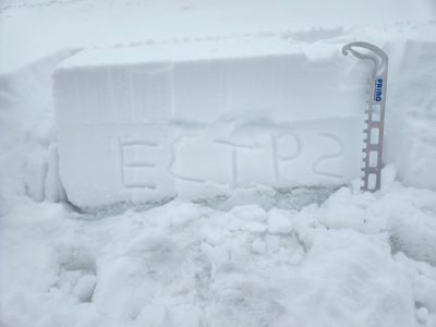
Pits on NE-E-SE 8600-8800': No crust observed below today's storm snow on E-NE. On E-SE and SE, thin crust (15-20cm down) with small FC above and below - ECTP2, ECTP4, ECTP3, ECTN. The slab above the crust was soft (4F) and thin where I dug, so no significant issues at this point. This layer could be a problem on slopes that received more snowfall and/or wind-loading.
No observations below old, hard ice crust from March warm spell.
Avalanche Problems
No obvious avalanche problems where I traveled today. Middle elevation winds appeared to be variable/erratic today and did not create wind slabs. Any wind slab problems were in terrain above where I was. Any possible wet loose issues were confined to lower elevations in this zone. I would have been leery of slopes with more than a foot of dense or wind-affected snow above the crust+facet layer that formed yesterday on E-S-W aspects, but I didn't see any terrain with a thick or stiff slab above that weak layer.
Terrain Use
I planned to avoid all big or consequential, wind-loaded avalanche paths. I did not see anything to change my plan.