Basic Information
Observation Details
Observation Date:
June 1, 2022Submitted:
June 1, 2022Observer:
ProZone or Region:
Challis Area and Lost RiversLocation:
Lost River Peak - Super Gully (S-W; 7600-11,000')Signs of Unstable Snow
Recent Avalanches?
YesCracking?
None ExperiencedCollapsing?
None ExperiencedSnow Stability
Stability Rating:
FairConfidence in Rating:
ModerateStability Trend:
WorseningBottom Line
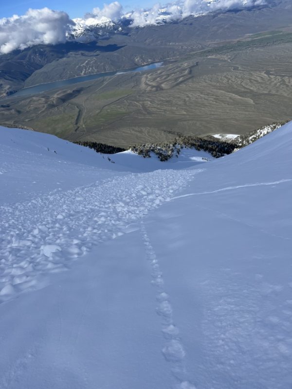
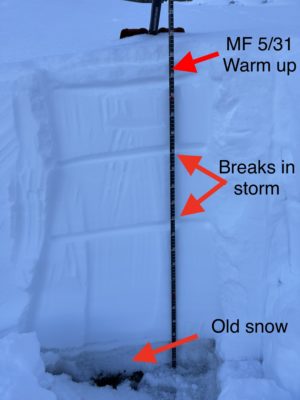
There was way more snow than I was predicting based off the Hilts Creek Snotel (SWE 1.5"). We found close to 1 meter of new snow since 0529 and a widespread Wet Loose cycle yesterday afternoon on S-SW aspects. Within the new snow, there were two distinct hardness changes that warranted attention. After some mixed stability results, we chose to retreat from the objective.
Media/Attachments


Advanced Information
Weather Summary
Cloud Cover:
Partly CloudyWind:
Light , SWNew/Recent Snowfall:
HN24: 5cm, HST: 95cmClear skies this morning with clouds forming over the mountain tops in the Lost and White Knobs. Strong solar radiation on exit in the lower elevations.
Avalanche Observations
There were numerous D1-1.5 Wet Loose avalanches on S-SW-W of all elevations. It seems like there was a clearing yesterday afternoon and/or increased ambient temperatures that triggered this natural cycle.
Snowpack Observations
I dug two test pits on the ascent and found two distinct hardness changes during the storm. After looking at the Hilts Creek snotel data, there were two small breaks in snowfall which align with the layering. The second pit at 11k produces one ECTP27 dn 30cm. Two more ECTs didn't reproduce the same results, but with multiple CTM SP on that same layer, it was enough uncertainity to pull the plug on going up further.

Avalanche Problems
| Problem | Location | Distribution | Sensitivity | Size | Comments |
|---|---|---|---|---|---|
 Wet Loose
|
|
Comments: Natural cycle backed this evidence up. |
|||
 Storm Slab
|
|
Layer Depth/Date: 30cm/0530 Comments: ECTP27 x1, CTM SPx3 |
Storm Slab is a short term problem that will likely heal within the next 24 hours or be tested by today and tomorrow's warming trend.
Terrain Use
I went into the day with an Assessment mindset as I haven't been into the Lost River Range this season and there was a new snow load. We avoided going up higher as the HST kept increasing with elevation and it seemed the safety marign was decreasing with a large amount of new snow. The Super Gully is not a great terrain feature to go for a ride in and we were approaching the steep headwall.

