Pro Field Report
Basic Information
Observation Details
Observation Date:
November 28, 2022Submitted:
November 29, 2022Observer:
SAC - VandenBos, PreussZone or Region:
Sawtooth and Western Smoky MtnsLocation:
Alturas Lake Creek Drainage (7,000-9,400', primarily northern half of the compass with some low elevation south)Signs of Unstable Snow
Recent Avalanches?
YesCracking?
IsolatedCollapsing?
IsolatedSnow Stability
Stability Rating:
FairConfidence in Rating:
LowStability Trend:
SteadyBottom Line
A minor storm buried the weak snow that developed during the November drought. 6-8" of low density new snow was enough to create conditions for remotely triggering avalanches. This surface is certain to produce additional avalanche activity during the storm later this week.
Media/Attachments
Advanced Information
Weather Summary
Cloud Cover:
OvercastWind:
Light , NWNew/Recent Snowfall:
12cm at highway, increasing to 20cm at upper elevations. It snowed about 1cm while we were out in the field.Periods of muted sunshine and flurries of S1 precipitation. The temperature dropped through the day. Winds blowing light out of the NW with occasional stronger gusts.
Avalanche Observations
| # | Date | Location | Size | Type | Bed Sfc | Depth | Trigger | Photos | Details |
|---|---|---|---|---|---|---|---|---|---|
| 1 |
Nov 28, 2022 3:30 pm (Exact) |
Alturas Lake Creek Drainage NE 9200ft |
D1.5 | SS-Soft Slab | I-New/Old Interface | 0.5ft |
AS-Skier r-Remote |
Report |
| # | Date | Location | Size | Type | Bed Sfc | Depth | Trigger | Comments | Photo |
|---|---|---|---|---|---|---|---|---|---|
| 1 |
Eureka Creek E 8800' |
D1.5 | SS | I-New/Old Interface |
AS-Skier r-Remote |
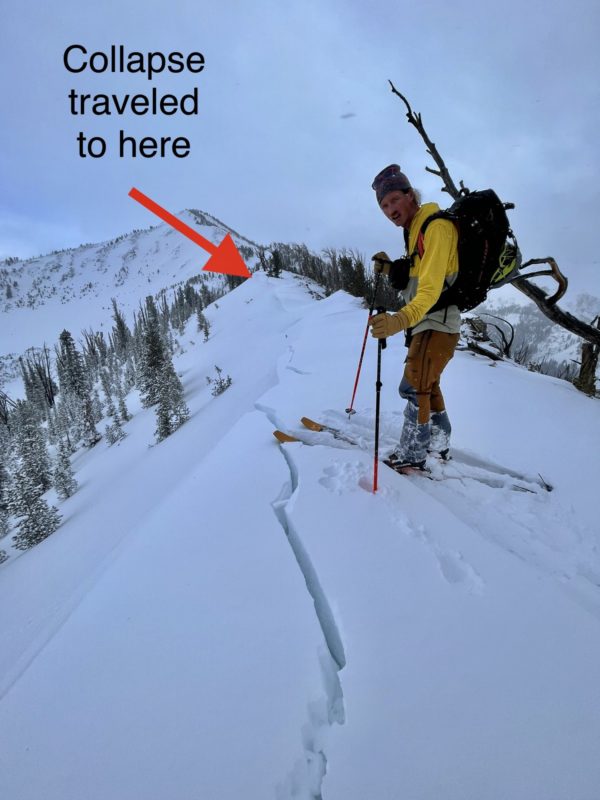
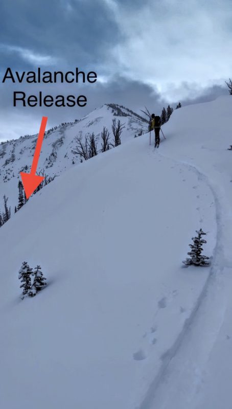
We couldn't safely get down to the crown to confirm depth, but it likely failed on the n/o interface. Ben was able to trigger from ~100' above on the ridgeline in low angle terrain. The collapse wrapped around on either side, running about ~500' away from the triggered location. | None |
The remote trigger told us that the storm snow was thick enough to act like a slab. The flanks of the avalanche path were spider webbed with cracks, but it appears like the slab wasn't strong enough to produce a larger avalanche in this terrain.
Snowpack Observations
Snowpack tests were in conducted in relatively sheltered areas and produced low ECTP results with only a couple of taps. The results failed on a weak interface of mixed facets and surface hoar at the new/old interface (November drought). October snow was present, but not as weak in structure as other observed areas.
Avalanche Problems
| Problem | Location | Distribution | Sensitivity | Size | Comments |
|---|---|---|---|---|---|
 Persistent Slab
|
|
Layer Depth/Date: 20cm Comments: Rose reflects where we observed. |
We observed weak snow underlying storm snow in much of the terrain we traveled through today. Areas that received more wind and snow are creating a more cohesive slab. We found surface hoar from the valley floor up into tree-line and it was even found in fairly dense forest cover.
Terrain Use
We avoided avalanche terrain and skied conservatively through pockets of steeper terrain in gladed areas.