Pro Field Report
Basic Information
Observation Details
Observation Date:
November 29, 2022Submitted:
November 30, 2022Observer:
SAC - VandenBos, DavisZone or Region:
Galena Summit and Eastern MtnsLocation:
Pole Creek (7,200-10,100', mostly southern half of the compass)Signs of Unstable Snow
Recent Avalanches?
YesCracking?
IsolatedCollapsing?
IsolatedSnow Stability
Stability Rating:
GoodConfidence in Rating:
ModerateStability Trend:
SteadyBottom Line
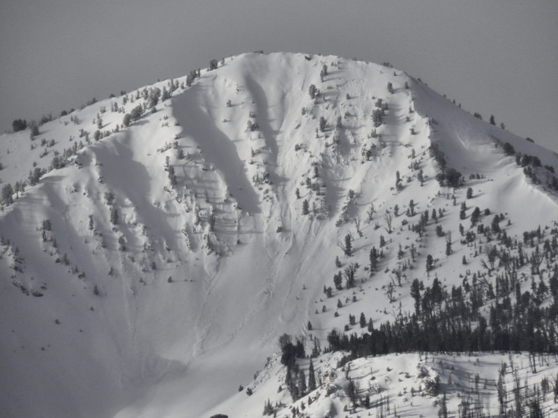
Sunday and Monday's storm produced natural avalanches in the southern Sawtooths and White Clouds. Avalanches failed in near and above treeline areas where the new snow was stiffened by the wind. Coverage in the White Clouds is remarkably good, even on generally scoured or burned-off W-SW-S facing slopes.
We found very weak snow on all slopes both at the surface and near the ground. This weak snow will not stand up to Wednesday-Thursday's storm snow. We expect widespread avalanching in this area.
Media/Attachments
Advanced Information
Weather Summary
Cloud Cover:
Partly CloudyWind:
CalmNew/Recent Snowfall:
HN: settled 10-12cm at Smiley Creek, 13-15cm as we climbed above Pole CreekThin, low, icy clouds hanging over the crest of the Sawtooths for much of the day, periodically moving out the valley and then pulling back. The White Clouds were cloud free for much of the day. Cloud cover increased in the afternoon and low clouds were hanging over most of the mountain ranges (Boulders, Smokys, White Clouds, Sawtooths, Pioneers) by late afternoon.
Avalanche Observations
| # | Date | Location | Size | Type | Bed Sfc | Depth | Trigger | Photos | Details |
|---|---|---|---|---|---|---|---|---|---|
| 3 |
Nov 28, 2022 (+/- 1 day) |
Eureka Peak E 10000ft |
D1.5 | SS-Soft Slab | I-New/Old Interface | 1ft | N-Natural |
|
Report |
Sunday and Monday's storm produced natural avalanches in the southern Sawtooths and White Clouds. Avalanches failed in near and above treeline areas where the new snow was stiffened by the wind.
Snowpack Observations
Pole Ck, Twin Ck - 8400', W, HS 60cm: (11/27) is buried under 13cm of recent snow. In this location, there was a thin (1cm) crust. (11/1) is down 55 cm. The whole snowpack was very weak. Essentially new snow sitting on a pile of facets bounded on either end by (11/27) and (11/1), which rested on a slick MFcr welded to the ground.
Avalanche Problems
| Problem | Location | Distribution | Sensitivity | Size | Comments |
|---|---|---|---|---|---|
 Persistent Slab
|
|
Layer Depth/Date: 13cm, (11/27) Comments: Shaded where I'd expect avalanches following the storm. SW and S aspects may have muted activity where snowpack is thin (lower elevations) or where the crust is thicker and (11/27) was less concerning (middle to upper elevations). |
|||
|
Persistent Slab
|
|
Layer Depth/Date: 55 cm, (11/1) Weak Layer(s): Nov 1, 2022 (FC) Comments: Widespread weak snow at the base of the snowpack. I expect that it will be hard to tell the difference between avalanches that fail on (11/27) and (11/1) in this zone. |
Terrain Use
We felt comfortable skiing terrain that lacked a cohesive slab of new snow. We avoided stiffer, wind-blown pockets of snow at middle and upper elevations.