Pro Field Report
Basic Information
Observation Details
Observation Date:
December 26, 2022Submitted:
December 27, 2022Observer:
SAC - Scott Savage, BogertZone or Region:
Galena Summit and Eastern MtnsLocation:
Baker Ck (Mostly S-SE and some E: 7200-9200')Signs of Unstable Snow
Recent Avalanches?
None ObservedCracking?
None ExperiencedCollapsing?
None ExperiencedBottom Line
We observed a sticky, soft, spring-like snowpack on S-SE aspects from 8000-8400'. From 8400-9000', the surface layers were wet. We did not see any significant wet loose avalanches, just rollerballs from yesterday and today. While we didn't experience any obvious signs of instability, I don't trust the stability while the snowpack has gone from a huge storm>>artic cold>>major wind event>>major warm-up with some wet snow...in a week. With Tuesday's expected 2" of SWE+strong winds+warm temps following the various atypical weather events stacked on top of each other over the past 6 days, I'll be expecting to see some interesting activity. Weird weather makes weird avalanches.
Advanced Information
Weather Summary
Cloud Cover:
Mostly CloudyTemperature:
Warm - estimated above 0 C from noon-4PM below 8600'Wind:
Light , SWNew/Recent Snowfall:
Some brief periods of S-1 (rimed crystals and pellets) from 8800-9200' from 1:30-3:30 PM.Wind varied from Light to Moderate on the Baker-Brodie Divide, but there is very little snow available for transport. Clouds ranged from PC to obscured with a 10-11K ceiling from about 2-4 PM.
Avalanche Observations
| # | Date | Location | Size | Type | Bed Sfc | Depth | Trigger | Photos | Details |
|---|---|---|---|---|---|---|---|---|---|
| 1 |
Dec 21, 2022 (+/- 1 day) |
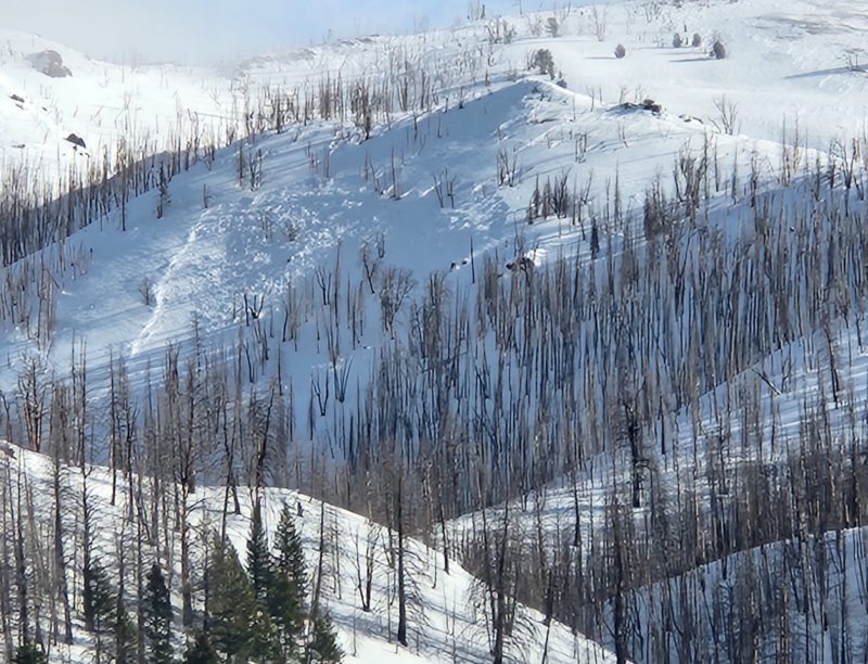
Baker Ck: between Cunard and Lost Shirt W 9100ft |
D2 | U-Unknown | O-Old Snow | N-Natural |
|
Report |
Snowpack Observations
I focused on solar aspects today. HS=30-95cm with mostly 70-85cm. Ski Pen = 0-15cm, boot pen = 15-40cm where tested. The upper 0.5-1.5cm of the snowpack was wet to very wet on S and SE aspects below 9000', and the upper ~20cm was moist. The surface was beginning to refreeze in wind-exposed terrain above 8800' at 3PM. Stark difference between SE and E aspects: you could move literally a few feet and change from a snowpack obviously getting wet to a dry, wintry snowpack. The extent of wet/very wet snow and moist snow farther below the surface was variable, probably due to the upper snowpack variability (hardness, loading, scouring, etc) produced by the Solstice wind event. The rain crust that formed at the tail end of the last big storm displayed a different pattern here: instead of thickening as elevation increased, it thinned and/or disappeared above 8500' on the wind-exposed slopes we traveled on. The bottom 2/3 of the snowpack looked pretty good, and the ground was damp/mud.
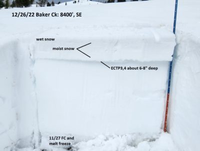
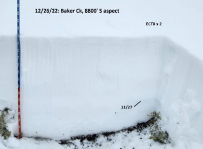
Test results: ECTP3, ECTP4 on small FC above a crust matrix (12/19) about 15 cm down on S-SE near 8400'. These results were not repeatable in other locations, and other locations did not have the multi-crust matrix associated with the 12/19 "layer". Somewhat surprisingly, I did not get any breaks/results on the 11/27 or 12/8 PWLs. Excluding the easy ECTP results on 12/19, all results would have been ECTX. 12/8 was non-existent or extremely subtle in this area.
See pit photos - I'll attach Snowpilot profiles Tuesday morning 12/27/2022.
Avalanche Problems
| Problem | Location | Distribution | Sensitivity | Size | Comments |
|---|---|---|---|---|---|
 Persistent Slab
|
|
Layer Depth/Date: 15-20cm Weak Layer(s): Dec 19, 2022 (FC) Comments: ECTP3,4 on this layer. Not a big concern today, but it's worth noting going into a big storm. This layer ranged in presentation from a multi-layered crust+facet matrix to a razor crust and was sporadic today: spooky around 8400', and a non-issue above about 8700' where we traveled. |
|||
 Wet Loose
|
|
Layer Depth/Date: surficial Comments: We didn't see any fresh activity, but the upper snowpack was wet enough that perfect paths (>40* in wind-sheltered terrain on SW-S-SE with soft snow near the surface) could have been problematic. |
I only noted the problems we directly observed.
Terrain Use
We planned to avoid avalanche starting zones and tracks and stuck with the plan.