Pro Field Report
Basic Information
Observation Details
Observation Date:
December 28, 2022Submitted:
December 29, 2022Observer:
SAC - DavisZone or Region:
Galena Summit and Eastern MtnsLocation:
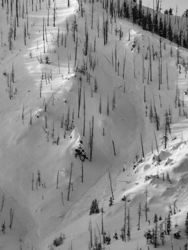
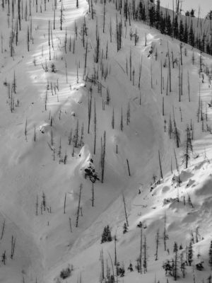
Prairie Peak (Primarily S-SE-E-NE, 7,000-9,400')Signs of Unstable Snow
Recent Avalanches?
YesCracking?
IsolatedCollapsing?
None ExperiencedSnow Stability
Stability Rating:
GoodConfidence in Rating:
ModerateStability Trend:
SteadyBottom Line
With somewhat limited visibility, I did not observe natural avalanches in the southern Boulders or Smokys near Prairie Ck. A weak layer of snow buried 1.5 to 2' deep was concerning particularly on wind-loaded slopes.
Media/Attachments
Advanced Information
Weather Summary
Cloud Cover:
Mostly CloudyTemperature:
20s FWind:
Light , NWNew/Recent Snowfall:
HST = 35-50 cm, HN = 15 cmLight wind from the W and NW. 15 cm of low-density snow available for transport, more than that with strong wind. Very light snowfall during daylight hours with no real accumulation.
Avalanche Observations
| # | Date | Location | Size | Type | Bed Sfc | Depth | Trigger | Comments | Photo |
|---|---|---|---|---|---|---|---|---|---|
| 1 |
Griffin Butte NE 7,400 |
D1.5 | SS | N-Natural |
|
Snowpack Observations
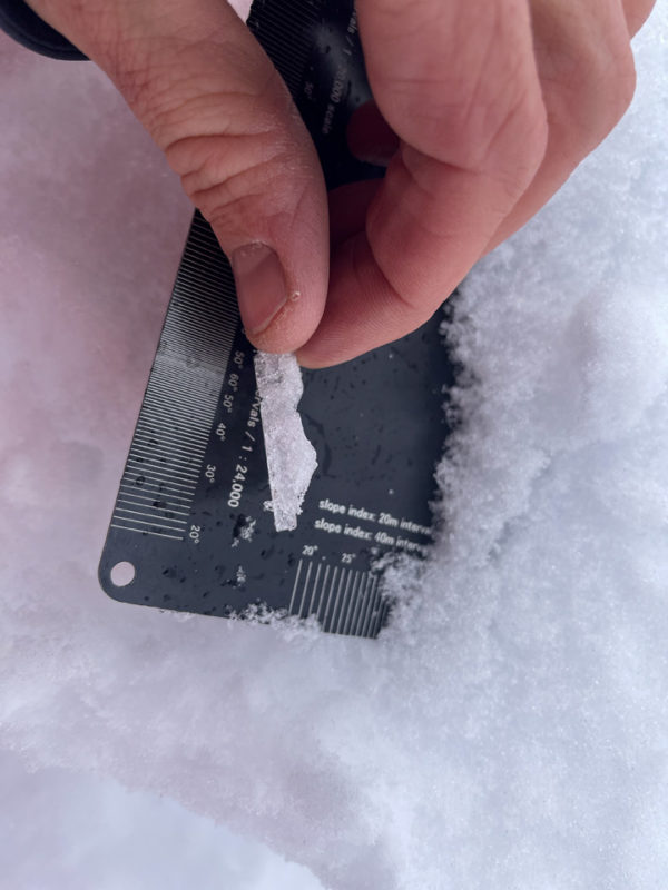
Rain line, New/Old, Surface Obs: There was ~15 cm of low density (F-) snow over 20-30 cm of heavier (4F) snow. The new/old interface was a rain crust below about 7,300' that disappeared by 7,500'. Above that it was a stout 3 cm melt-freeze crust (sunnier slopes) or rounded grains (shaded slopes), or something on a continuum between the two. It did not produce any concerning results and was well-bonded where I dug.
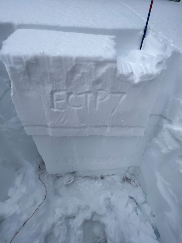
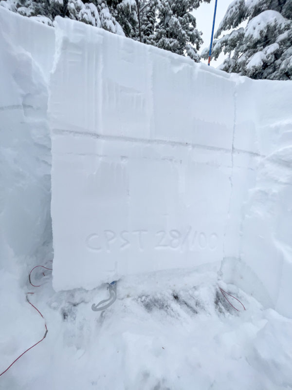
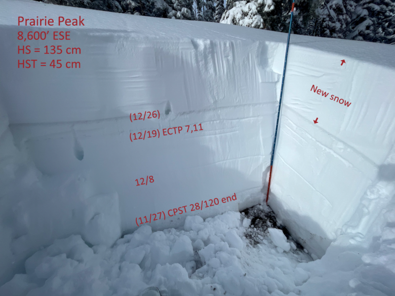
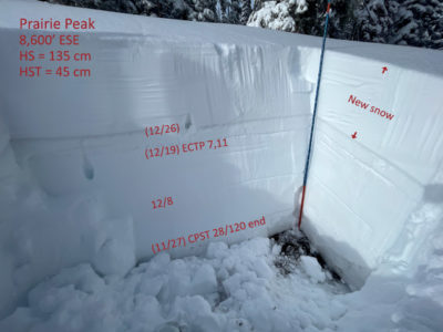
ESE @ 8,700', HS = 135 cm, HST = 53 cm: This pit was in a mostly sheltered small clearing."12/19" dn 53 cm produced ECTP 7, 11 under a faceting, brittle rain crust. (See photos). "12/8" was detectable as a half-step hardness change and subtly more faceted but produced ECTX. "11/27" was rough, moist and 4F+. It produced ECTX and CPST28/100 end.
Avalanche Problems
| Problem | Location | Distribution | Sensitivity | Size | Comments |
|---|---|---|---|---|---|
 Persistent Slab
|
|
Layer Depth/Date: 35-50 cm, 12/19 Weak Layer(s): Dec 19, 2022 (FC) Comments: I suspect 12/8 would also be on my radar had I traveled on more shaded aspects. Seems most likely to be triggered where a fresh wind slab rests near the surface. That said, Scott was getting ECTPs on this layer prior to the storm. |
"11/27" is buried more than a meter in this region beneath a 1F+ slab and is somewhere between stubborn and unlikely to trigger.
Terrain Use
I felt comfortable on short, supported, steeper slopes without an obvious recent wind-load. I avoided wind-loaded terrain. Steep W-N-E still give me the most hesitation due to a higher number of better developed weak layers.