Pro Field Report
Basic Information
Observation Details
Observation Date:
January 24, 2023Submitted:
January 24, 2023Observer:
SAC - Scott SavageZone or Region:
Soldier and Wood River Valley MtnsLocation:
E Fork Baker Ck - Fox Peak (6700-9100', mostly 8600-9100': all aspects but minimal travel on S, N, or NE)Signs of Unstable Snow
Recent Avalanches?
None ObservedCracking?
IsolatedCollapsing?
None ExperiencedSnow Stability
Stability Rating:
GoodConfidence in Rating:
ModerateStability Trend:
Bottom Line
Recent and ongoing winds formed hard slabs up to about a foot thick just below exposed ridgelines around 9000'. The slabs did not extend far below the ridgeline and were difficult to trigger/crack, but they were very hard and hollow sounding + feeling. The weak layers buried 1-2 feet deep existed on all aspects near 9000' and did not look great, but they did not produce any unstable results in snowpack tests.
Media/Attachments
Advanced Information
Weather Summary
Cloud Cover:
Partly CloudyTemperature:
Teens FWind:
Strong , NNew/Recent Snowfall:
HN=3-8cm in recent days (since the road was groomed)Skies began clear around noon and were obscured with S-1 by 4 PM. Winds were moderate-north before 2 PM, strong-north from 2-4 PM, and decreasing to moderate from 4-4:45 PM. The afternoon wind event drifted the road (down to near 7000') with snow, scattered pine needles and boughs all over, and dumped a lot of tree bombs. Large plumes were coming off Osberg Ridge, but the wind-blown snow appeared to be mostly sublimating. The wind has transported most of the "easily-transported" snow.
Avalanche Observations
| # | Date | Location | Size | Type | Bed Sfc | Depth | Trigger | Comments | Photo |
|---|---|---|---|---|---|---|---|---|---|
| 1 |
E Fork Baker Ck N 8200 |
D1.5 | O-Old Snow | U-Unknown | May have been skier triggered, remotely? |
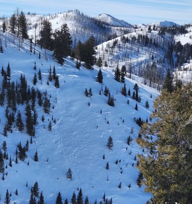
|
Unknown release date on the pictured slide. I may add additional photos of old avalanches Wed morning, Jan 25, after reviewing my photos.
Snowpack Observations
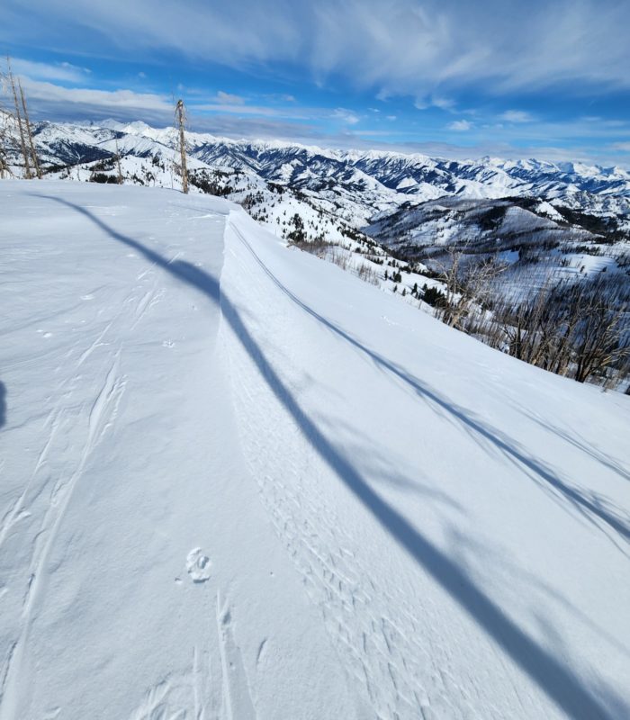
I focused on the highest terrain (near 9000') that was wind-sheltered enough to preserve weak layers and not develop wind slabs but exposed enough to see subtle wind effects. The structure at 1/5 and 12/19 remains concerning, but all ECT results were ECTN or X on these individual layers. Above 8600', HS=120-170cm.
The most notable observation is how weak the upper 15-25cm of the snowpack is: a mix of SH, FC, and delicate PP/DF with a thin razor crust on the top on S-SW.
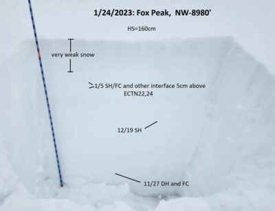
NW 8980' (see photo below): HS=160cm, 1/5 down 35cm (3-4mm SH and some FC underneath a thin degrading wind/rime crust), 12/19 down 65cm (3-8mm SH, mostly laying down but some upright). ECTN22,21@30cm down (a thin FC interface just above 1/5), ECTN24@35cm down (1/5).
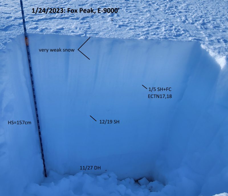
E 9000' (see photo above): HS=157cm, 1/5 down 32cm (FC, SH shards), 12/19 down 62cm (SH, not upright). ECTN17,18 @ down 32cm (1/5), no results on 12/19.
SE 9050' (SnowPilot profile coming on Wed, 1/25): HS=130cm, 1/5 down 30cm (SH shards with nice FC above), 12/19 down 65cm (SH 3-5mm not upright). ECTN19,18 @down 30cm (1/5), ECTN28 and no result @down 65cm (12/19).
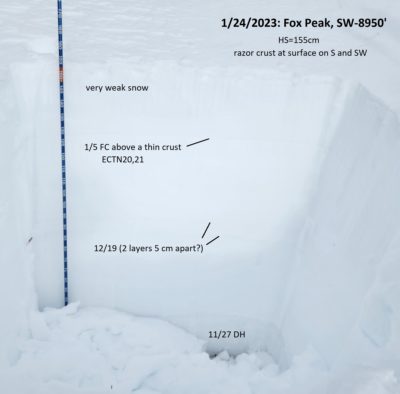
SW 8950' (see photo below): HS=155cm, 1/5 down 30cm (FC above a crust), 12/19 presented as 2 layers down 65-72cm. ECTN20,21@down 30cm (1/5), no ECT results on any other layers.. Multiple layers just above and below 12/19, as well as the top of 11/27, produced clean shears when prying on blocks after doing ECT tests.
Avalanche Problems
| Problem | Location | Distribution | Sensitivity | Size | Comments |
|---|---|---|---|---|---|
 Persistent Slab
|
|
Layer Depth/Date: 30-35cm Weak Layer(s): Jan 5, 2023 (SH) Dec 19, 2022 (FC) Comments: Shaded area indicates where I traveled and observed persistent weak layers at the 1/5 interface (SH and FC) and 12/19 interface (mostly SH except FC on SW aspect). All test results on 1/5 were ECTN 17-24. On 12/19, I got a single ECTN24 and 7 x "no results". |
|||
 Wind Slab
|
|
Layer Depth/Date: <30cm Comments: Shaded area indicates where I encountered recently formed hard slabs. They were P to K hard but only extended 10-30 feet below ridgelines. Of the 6 or 7 I stomped on, only one of them cracked. |
Terrain Use
I was traveling solo and stayed out of all starting zones. I did not travel in any avalanche path tracks other than while on the road.