Public Field Report
Observation Details
Observation Date:
March 6, 2023Submitted:
March 6, 2023Zone or Region:
Soldier and Wood River Valley MtnsActivity:
Skiing/SnowboardingLocation:
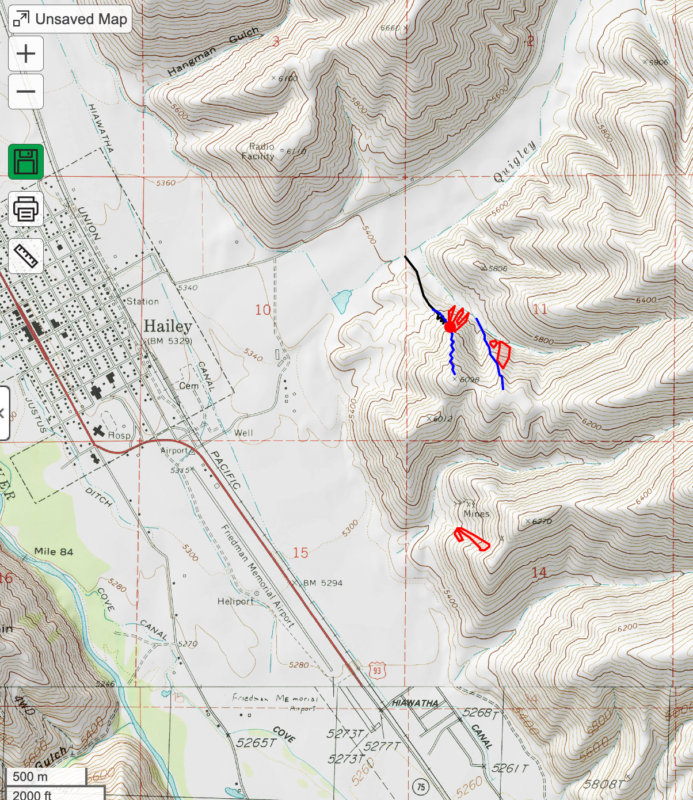
Quigley CanyonTriggered Avalanches
Did you trigger any avalanches?
YesWas it intentional?
YesAvalanche Type:
Soft SlabSize:
Size 2: Could bury, injure, or kill a personElevation:
5800 to 5900 feetAspect:
NComments:
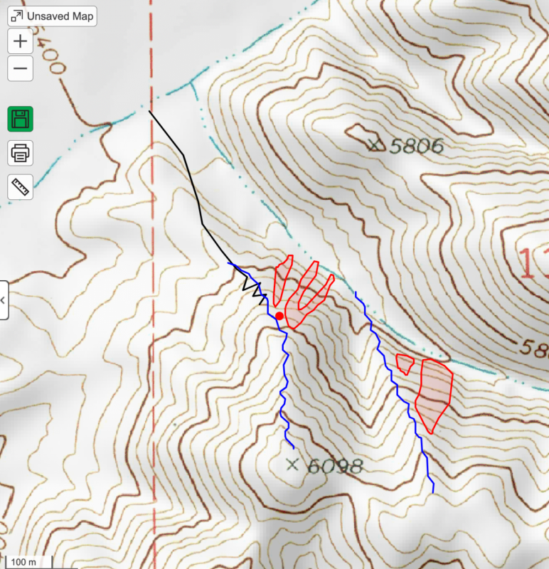
When skiing my second line (the right/eastern most blue line on the map) I remotely triggered the face to my right. I did not feel any collapsing or whumping while skiing, but at the bottom I looked back up to see if I triggered a slide and they were still coming down the slope. Main observation/story continued below.Observed Avalanches
Did you observe any avalanches?
YesAvalanche Type:
Soft SlabSize:
Size 2: Could bury, injure, or kill a personElevation:
7200 - 7600Aspect:
WComments:
We watched two skiers remotely trigger three pockets while climbing up a ridge above the pump park out quigley canyon. The slides ran into the "Many Sided B-Canyon" that contains the southern most loop of the nordic trails. The pair that triggered the slides stopped climbing and descended their skin track (black line on my maps). Main observation/story continued below.Signs of Unstable Snow
Did you see shooting cracks?
Yes, IsolatedDid you experience collapsing or whumpfing?
Yes, WidespreadObservations
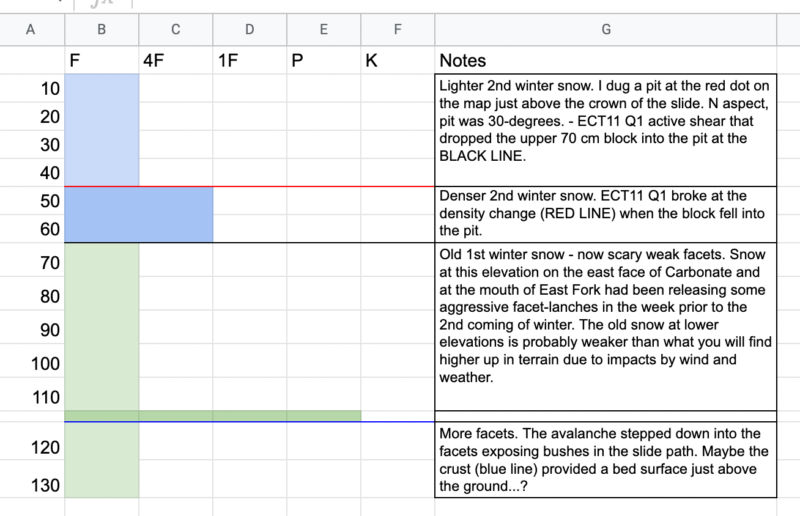
After watching the two skiers trigger the avalanches this afternoon around 12:30 PM, I climbed up to investigate (and ski some powder) this afternoon around 4:00 PM. I continued up the skin track used by the earlier pair of skiers (black skin track) and continued up the ridge (my uptrack is not marked on the map). I stopped to look at the slide on the way up. It appeared to break at the 1st winter/2nd winter boundary but stepped deeper into the facets. There were grass and bushes exposed by the slide. It could have been running on the crust near the ground (see my pit profile), but I did not walk out onto the bed surface to investigate. As I continued up the slope, there were cracks from the slide that extended back into 20-degree slopes. I thought I might be able to trigger a slide from higher up the ridge below pt. 6098, but did not get that much sensitivity on the ridge. I think the wind slab had some more strength and was therefore not as sensitive. On my first ski back down the ridge, I did trigger some shooting cracks just downhill and skiers left of the slide, but the slope was not steep enough to slide.
On my second climb back up the ridge, I did take the time to stop and dig a pit about 20 feet back from the crown of the slide. My pit was north facing and on a 30 degree slope. I have attached a profile and comments with results of a single ECT.
I continued up the ridge with the intention of skiing the next NW ridge out the canyon. I thought I might be able to remotely trigger the north side of that ridge. When I got to the bottom and looked back up there were two slides just reaching the valley floor. I did not experience any obvious whumping or cracking while skiing my second line (skiers right blue line on the map).
Additionally, when I crested pt. 6098 I observed the other two slides further south (also drawn on the map). One of these slides had a fresh track crossing the crown wall. I could not see any exit tracks (except at the very bottom) so I assume the skier took a small ride and hopefully was not buried. There were also three more higher elevation slides (not drawn on the map) on the western slopes around 7200 feet below pt 7653 on the main Cowcatcher Ridge. These did not look like they stepped deeper into the 1st winter snow, but just involved the newer 2nd winter snow.
Sorry, I left my camera in the car, but can and will send some snaps from the Sage School campus tomorrow with good light.
Ski quality was Very Good!
Media